Влезте
Всички ресурси
Създаване на дизайн
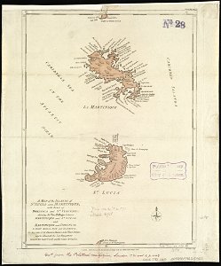
A map of the islands of St. Lucia and Martinique, with part of Dominica and St. Vincents, shewing the two passages between Martinique and St. Lucia, and Martinique and Dominica, to Fort Royal Bay and (4586550441)
Изтегляне
Редактиране на изображение
Публикувано от:
Creazilla
Автор:
Norman B. Leventhal Map Center at the BPL
Източник:
commons.wikimedia.org
Loading...
0 stažení
Печат
Копиране на изображение
Зареждане...
18th-century maps of martinique
john lodge (engraver)
old maps of saint lucia
1781 maps
old maps of saint lucia from the norman b. leventhal map center
old maps of martinique from the norman b. leventhal map center
ПОДОБНИ