Log in
All resources
Create a design
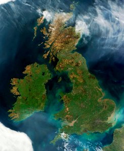
Nearly cloud-free view of Great Britain and Ireland was acquired by the Moderate Resolution Imaging Spectroradiometer aboard NASA’s Terra satellite on March 26, 2012.
Download
Edit image
Published by:
Creazilla
Author:
NASA
Source:
rawpixel.com
Loading...
0 downloads
Print it
Copy image
Loading...
maps
landscape
space
ocean
fall
ireland
nasa
world
world map
climate change
great
ireland map
MORE LIKE THIS