Log in
All resources
Create a design
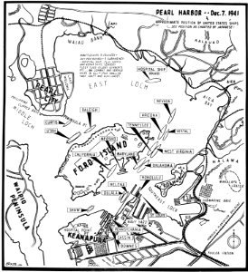
Map of Pearl Harbor, Hawaii, with approximate position of ships on 7 December 1941 (80-G-47105)
Download
Edit image
Published by:
Creazilla
Author:
U.S. Navy photo 80-G-47105
Source:
commons.wikimedia.org
Loading...
0 downloads
Print it
Copy image
Loading...
history
historical
skiptag
maps of the pearl harbor attack
MORE LIKE THIS