Log in
All resources
Create a design
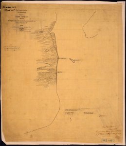
Map of Pass Cavallo, Texas, Showing the position of the Rebel fortifications and rifle pits. Surveyed December 1st... - NARA - 305795
Download
Edit image
Published by:
Creazilla
Author:
Charles Hosmer, Sub-Assistant, [U.S. Coast Survey]
Source:
commons.wikimedia.org
Loading...
0 downloads
Print it
Copy image
Loading...
history
historical
texas
skiptag
1863 maps
old maps of the gulf of mexico
old maps of texas in the american civil war
calhoun county
MORE LIKE THIS