Log in
All resources
Create a design
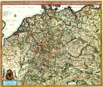
Atlas Van der Hagen-KW1049B10 047-S. IMPERIUM ROMANO-GERMANICUM oder DEUTSCHLAND MIT SEINEN ANGRÄNTZENDEN KÖNIGREICHEN UND PROVINCIEN Neulich entworffen und theils gezeichnet durch IULIUM REICHELT Chur Pfaltz
Download
Edit image
Published by:
Creazilla
Author:
Nicolaes Visscher II (1649–1702)
Source:
commons.wikimedia.org
Loading...
0 downloads
Print it
Copy image
Loading...
german empire
east germany
west germany
german reunification
weimar republic
nazi germany
north german confederation
reichsadler
german diaspora
history of germany
18th-century history of germany
maps with cartouches
confederation of the rhine
history of saxony
military history of germany
german confederation
atlas van der hagen
atlas van der hagen (volume 1)
1680s maps of the holy roman empire
flight and expulsion of germans (1944–1950)
migration period
kingdom of prussia
history of germany (1945–1990)
german reich
unification of germany
list of years in germany
east francia
allied-occupied germany
kingdom of germany
kleinstaaterei
history of german
history of germany during world war i
economic history of germany
names of germany
new states of germany
germany in the early modern period
history of germany (1990–present)
old states of germany
MORE LIKE THIS