Log in
All resources
Create a design
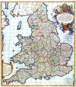
Atlas Van der Hagen-KW1049B11 004-A NEW MAP OF THE KINGDOME of ENGLAND, Representing the Princedome of WALES, and other PROVINCES, CITIES, MARKET TOWNS, with the ROADS from TOWN to TOWN
Download
Edit image
Published by:
Creazilla
Author:
Nicolaes Visscher II (1649–1702)
Source:
commons.wikimedia.org
Loading...
1 download
Print it
Copy image
Loading...
somerset
english society
coats of arms of king william iii of england and ii of scotland
history of england
stuart period
maps with cartouches
england in the middle ages
atlas van der hagen
glorious revolution
timeline of cambridge
old maps of england
atlas van der hagen (volume 2)
anglo-normans
exclusion crisis
kingdom of england
privy council of england
history of anglo-saxon england
1689
declaration of right
list of years in the kingdom of england
history of milton keynes
black death in england
timeline of british diplomatic history
archaeology of anglo-saxon england
timeline of liverpool
timeline of leicester
timeline of plymouth
timeline of bath
timeline of kingston upon hull
timeline of bradford
timeline of exeter
timeline of norwich
timeline of southampton
timeline of bristol
timeline of nottingham
MORE LIKE THIS