AMH-7242-KB Map showing the road between Samarang and Cartasoera

AMH-7242-KB Map showing the road between Samarang and Cartasoera

Edit image
Published by:
Creazilla
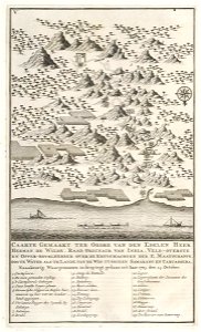
Author: Creator:J. van Braam Creator:Gerard onder de Linden Creator:Herman de Wilde Nederlands: Anoniem / Anonymous (landmeter / kaartenmaker), J. van Braam (uitgever), Gerard onder de Linden (uitgever), Herman de Wilde (opdrachtgever) English: Anoniem / Anonymous (land surveyor / mapmaker), J. van Braam (publisher), Gerard onder de Linden (publisher), Herman de Wilde (patron)Source: commons.wikimedia.org

Loading...

0 downloads
Loading...
18th-century maps of indonesia1724maps of the dutch east india company - indonesiakartasuramaps of semarang

MORE LIKE THIS

Creazilla logo
Over 10 million free graphic resources for content creators and designers.
© 2018 - 2025 Creazilla
Our resourcesAll imagesPhotosDigital illustrationsClipartIconsPNG ImagesEmojisSilhouettesTraditional Art3D ModelsVectorsFontsColor namesColor palettesGradientsAudioAnimationVideosTemplates
InformationAbout CreazillaTerms of useTech teamPrivacy policyLicence Information
FeedbackContact Us