Log in
All resources
Create a design
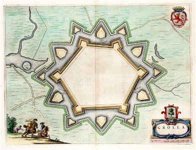
Grolla - Map of Groenlo, after 1628 (J.Blaeu, 1649)
Download
Edit image
Published by:
Creazilla
Author:
J.Blaeu
Source:
commons.wikimedia.org
Loading...
0 downloads
Print it
Copy image
Loading...
ravelins
maps by willem and johannes blaeu
maps made in the 17th century
17th-century fortress plans
atlas van loon
maps of fortifications
siege of groenlo 1672
old maps of groenlo
drawings of defensive walls
siege of groenlo
MORE LIKE THIS