Log in
All resources
Create a design
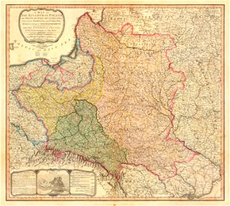
Map of the partition of the Kingdom of Poland and the Grand Duchy of Lithuania from 1799
Download
Edit image
Published by:
Creazilla
Author:
William Faden (1749–1836)
Source:
commons.wikimedia.org
Loading...
4 downloads
Print it
Copy image
Loading...
maps of the kingdom of galicia and lodomeria
maps by william faden
18th-century maps of estonia
1799 maps
old maps of latvia
old maps of partitioned poland
history maps of samogitia
old maps of the polish-lithuanian commonwealth
18th-century maps of latvia
volhynian voivodeship (1569–1795)
maps of ruthenian voivodeship
podolian voivodeship
belz voivodeship
maps of kiev voivodeship (1471-1793)
partitions of poland–lithuania
1799 maps of lithuania
haplogroup g-m377
MORE LIKE THIS