Log in
All resources
Create a design
Tools
8,201 Free Images of Documentary
bibliothèque nationale de france
marco boschini
guillaume sanson
maps of the islands of greece by marco boschini (1658)
drawings (documentary) collection in the library of congress
maps of ports and fortresses of the mediterranean by marco boschini (1651)
context files from gallica
19th-century pencil drawings
maps by willem and johannes blaeu
drawings by alfred waud
engravings by romeyn de hooghe
parc d’enghien in art
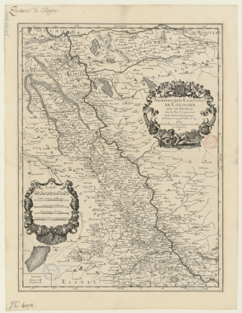
carte des pays-bas catholiques by guillaume sanson
bibliothèque nationale de france
map of the circle of bavaria by sanson
bibliothèque nationale de france
carte de la syrie by guillaume delisle (1764)
bibliothèque nationale de france
bibliothèque nationale de france
guillaume sanson
old maps of gâtinais and sénonais
maps by willem and johannes blaeu
old maps of norway
guillaume sanson
map of the circle of upper saxony by sanson
bibliothèque nationale de france
flandre espagnole et flandre hollandoise - par le sr. sanson - btv1b53042828k
guillaume sanson
17th-century maps of crete
old maps of candia
17th-century maps of crete
old maps of candia
old maps of the republic of genoa
maps by willem and johannes blaeu
maps of ancient italy by philipp clüver
bibliothèque nationale de france
maps of limburg by aegidius martini
bibliothèque nationale de france
maps of limburg by aegidius martini
bibliothèque nationale de france
bibliothèque nationale de france
maps by thomas kitchin
maps of lake geneva by jacques goulart
bibliothèque nationale de france
maps of damascus by braun & hogenberg
bibliothèque nationale de france
maps of limburg by aegidius martini
bibliothèque nationale de france
people
china
drawings by alfred waud
potomac river
historical images of palermo by gustave le gray
presa di palermo
drawings (documentary) collection in the library of congress
delaware water gap
17th-century maps of scotland
maps of islay
magni ducatus lithuaniae
maps facing west
maps of the islands of greece by marco boschini (1658)
history of kythira
old maps of antikythera
old maps of kythira
drawings (documentary) collection in the library of congress
1760 drawings
drawings (documentary) collection in the library of congress
drawings by kenyon cox
18th-century maps of edinburgh-shire
maps of scotland by herman moll
maps by hendrik hondius the younger
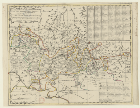
maps of the county of mansfeld
pierre moullart-sanson
guillaume sanson
maps of famagusta by braun & hogenberg
bibliothèque nationale de france
maps of île-de-france by françois de la guillotière
bibliothèque nationale de france
bibliothèque nationale de france
guillaume sanson
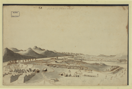
drawings of the american civil war
drawings by alfred waud
drawings (documentary) collection in the library of congress
frank leslie's illustrated newspaper, 1862
drawings (documentary) collection in the library of congress
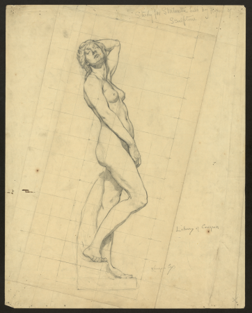
drawings by kenyon cox
drawings (documentary) collection in the library of congress
drawings by kenyon cox
maps of the islands of greece by marco boschini (1658)
context files from gallica
maps of the islands of greece by marco boschini (1658)
history of lesbos
17th-century maps of the netherlands
maps by pieter van der keere
drawings (documentary) collection in the library of congress
drawings by kenyon cox
drawings (documentary) collection in the library of congress
drawings by kenyon cox
carte des pays-bas catholiques by guillaume sanson
robert cordier (engraver)
bibliothèque nationale de france
guillaume sanson
maps by pieter mortier
maps from gallica
bibliothèque nationale de france
guillaume sanson
bibliothèque nationale de france
guillaume sanson
maps of ports and fortresses of the mediterranean by marco boschini (1651)
bibliothèque nationale de france
carte de la mer méditerranée en trois feuilles (dheulland et al.)
18th-century maps of the western mediterranean
bibliothèque nationale de france
guillaume sanson
maps of ports and fortresses of the mediterranean by marco boschini (1651)
bibliothèque nationale de france
maps of ports and fortresses of the mediterranean by marco boschini (1651)
palaiokastro
maps of the islands of greece by marco boschini (1658)
history of kythira
sanson maps of the netherlands
1680s maps of the netherlands
maps of the islands of greece by marco boschini (1658)
agathonisi
old maps of farmakonisi
old maps of agathonisi
context files from gallica
history of santorini
maps of the islands of greece by marco boschini (1658)
history of the sporades
maps by pieter mortier
maps from gallica
maps of lake geneva by jacques goulart
bibliothèque nationale de france
maps of lake geneva by jacques goulart
bibliothèque nationale de france
drawings (documentary) collection in the library of congress
drawings by alfred waud
historical images of narbonne
topographia galliae
maps by pieter van der keere
maps by abraham ortelius
old maps of the shetland islands
old maps of the orkney islands
maps of the islands of greece by marco boschini (1658)
old maps of lesbos
16th-century maps of crete
old maps of candia
context files from gallica
history of rhodes
maps by pieter van der keere
old maps of friesland
context files from gallica
history of samos
maps of ports and fortresses of the mediterranean by marco boschini (1651)
bibliothèque nationale de france
bibliothèque nationale de france
guillaume sanson
maps of ports and fortresses of the mediterranean by marco boschini (1651)
bibliothèque nationale de france
maps by pieter mortier
maps from gallica
maps of ports and fortresses of the mediterranean by marco boschini (1651)
bibliothèque nationale de france
bibliothèque nationale de france
guillaume sanson
bibliothèque nationale de france
guillaume sanson
maps of ports and fortresses of the mediterranean by marco boschini (1651)
bibliothèque nationale de france
bibliothèque nationale de france
guillaume sanson
maps by alexis-hubert jaillot
old maps of duchy of cleves
old maps of norway
guillaume sanson
maps of the islands of greece by marco boschini (1658)
old maps of euboea
1896 coronation book
classicism
drawings (documentary) collection in the library of congress
drawings by alfred waud
drawings (documentary) collection in the library of congress
drawings by alfred waud
carte de moscovie by guillaume de l'isle (1706)
bibliothèque nationale de france
maps of the islands of greece by marco boschini (1658)
bibliothèque nationale de france
maps of ports and fortresses of the mediterranean by marco boschini (1651)
bibliothèque nationale de france
old maps of rome
antonio lafreri
carte de la mer méditerranée en trois feuilles (dheulland et al.)
18th-century maps of the eastern mediterranean
map of the circle of swabia by sanson
bibliothèque nationale de france
carte de la mer méditerranée en trois feuilles (dheulland et al.)
old maps of the central mediterranean
carte des pays-bas catholiques by guillaume sanson
robert cordier (engraver)
bibliothèque nationale de france
guillaume sanson
maps of ports and fortresses of the mediterranean by marco boschini (1651)
bibliothèque nationale de france
maps of andalusia by mercator-hondius
bibliothèque nationale de france
leonard schenk jansz.
maps from gallica
maps of ports and fortresses of the mediterranean by marco boschini (1651)
bibliothèque nationale de france
5801 - 5900 of 8,201
Next page
/ 83


![Gastinois and Senonois / [Blaeu], 1631](https://cdn.creazilla.com/illustrations/10001540570/gastinois-and-senonois-blaeu-1631-sm.jpg)