Log in
All resources
Create a design
Tools
16,724 Free Images of Language
bibliothèque nationale de france
maps of the islands of greece by marco boschini (1658)
marco boschini
context files from gallica
historical
history
cc-zero
images from nationaal archief
images from anefo
guillaume sanson
17th-century maps of the holy roman empire
maps by pieter van der keere
1750s maps of the netherlands
hendrik de leth
bibliothèque nationale de france
guillaume sanson
a map of the british empire in america with the french and spanish settlements adjacent thereto
1730s maps of central america
bibliothèque nationale de france
braun/hogenberg dreizehn orte
maps of the islands of greece by marco boschini (1658)
old maps of andros
description of the nobility of hainaut by braun & hogenberg
bibliothèque nationale de france
1667 sanson map of africa
1702 maps of africa
maps of béthune by braun & hogenberg
bibliothèque nationale de france
maps of the islands of greece by marco boschini (1658)
old maps of naxos
territorium argentoratense (1652 map)
bibliothèque nationale de france
maps of the islands of greece by marco boschini (1658)
old maps of leros
bibliothèque nationale de france
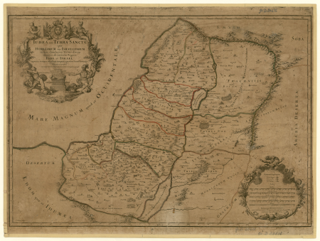
sanson maps of the holy land
bibliothèque nationale de france
prints by martin engelbrecht
bibliothèque nationale de france
carolus allard
maps of the islands of greece by marco boschini (1658)
old maps of amorgos
map of the strait of kerch by guillaume sanson
bibliothèque nationale de france
maps of brno by braun & hogenberg
bibliothèque nationale de france
map of ancient asia minor by philippe de la rué
bibliothèque nationale de france
maps by willem and johannes blaeu
17th-century maps of xaintonge
maps of liège by baptista van doetecum
maps by abraham ortelius
arnold van langren map of southwest africa
renaissance
a topographical map of the county of berks (1761)
bibliothèque nationale de france
cartouches by willem and johannes blaeu
bibliothèque nationale de france
16th-century maps of switzerland
ferrando bertelli
a topographical map of the county of berks (1761)
bibliothèque nationale de france
maps by willem and johannes blaeu
old maps of berry
landscape
building
historical
history
historical
history
historical
history
historical
history
historical
history
historical
history
historical
history
historical
history
eran laor cartographic collection
gerard de jode
eran laor cartographic collection
gerard de jode
grzegorz fitelberg
fritz reiner
jean-françois-thérèse chalgrin
academic art
women of morocco in art
georges bretegnier
black white cat patterns (image set)
svg feline icons
theatrum historium ad annum christi quadringentesinum by guillaume delisle (1705)
1740s maps showing history
context files from gallica
history of andros
maps from gallica
old maps of paris
maps by alexis-hubert jaillot
sanson maps of the holy land
old maps of milos
maps facing east
maps of peñón de vélez by braun & hogenberg
maps of tunis by braun & hogenberg
maps of the islands of greece by marco boschini (1658)
history of patmos
maps by willem and johannes blaeu
beausse
theatrum historium ad annum christi quadringentesinum by guillaume delisle (1705)
18th-century maps showing history
16th-century maps of crete
old maps of candia
maps of the islands of greece by marco boschini (1658)
history of kythnos
maps of the islands of greece by marco boschini (1658)
history of kalymnos
1690s maps of greece
maps from gallica
maps of the islands of greece by marco boschini (1658)
context files from gallica
context files from gallica
history of amorgos
1710s maps of the world
maps by edward wright
linguistic maps of the low saxon language
pd-user
maps of peñón de vélez by braun & hogenberg
maps of tunis by braun & hogenberg
maps of saint paul's journeys
maps by thomas starling
geological maps of england
william smith (geologist)
maps of the islands of greece by marco boschini (1658)
context files from gallica
laurens reael
willem blaeu
maps of bordeaux by braun & hogenberg
maps of nîmes by braun & hogenberg
maps of the islands of greece by marco boschini (1658)
history of ios
maps of the islands of greece by marco boschini (1658)
history of mykonos
maps of the islands of greece by marco boschini (1658)
history of leros
a map of the british empire in america with the french and spanish settlements adjacent thereto
1730s maps of the caribbean
texts about india
willem blaeu
chodorlahomoris aelamitarum regis et confoederatorum regna ; seu aelamitarum imperium, antiquitati a gulielmo sanson restitutum, magnas repraesentans regiones a mari aegaeo ad indumusque fluvium quibus... - btv1b531793037
guillaume sanson
maps of the islands of greece by marco boschini (1658)
context files from gallica
old county maps of hertfordshire
maps by thomas kitchin
map of the upper rhenian circle by sanson
maps by nicolas sanson
maps of spain by tomas lopez
1761 maps of spain
maps of spain by tomas lopez
1761 maps of spain
military
army
maps of the kingdom of córdoba (crown of castile)
maps of spain by tomas lopez
antoine-françois tardieu
maps from gallica
maps of cities in venezuela
maps by juan lopez
engravings by matthäus merian
baroque
charles-françois beautemps-beaupré
maps from gallica
1762 maps of north america
maps by tomas lopez
1800s maps of the iberian peninsula
maps of spain by tomas lopez
maps of the iberian peninsula by guillaume delisle
1700s maps of the iberian peninsula
world war i posters in the library of congress
maximilian lenz
16th-century maps of switzerland
ferrando bertelli
bibliothèque nationale de france
guillaume sanson
maps of ancient italy by philipp clüver
old maps of the alps
euonymus latifolius - botanical illustrations
flora by h. witte (pngs)
perspective de la ville de paris, veue du pont des tuileries - silvestre incidit - btv1b53181589j
bibliothèque nationale de france
maps of béthune by braun & hogenberg
bibliothèque nationale de france
bibliothèque nationale de france
guillaume sanson
china veteribus sinarum regio nunc incolis tame dicta
bibliothèque nationale de france
a map of the british empire in america with the french and spanish settlements adjacent thereto
1730s maps of the caribbean
a topographical map of the county of berks (1761)
bibliothèque nationale de france
maps of the islands of greece by marco boschini (1658)
old maps of kalymnos
china veteribus sinarum regio nunc incolis tame dicta
coats of arms on maps
tricyrtis hirta - botanical illustrations
flora by h. witte (pngs)
hydrangea macrophylla - botanical illustrations
flora by h. witte (pngs)
13701 - 13800 of 16,724
Next page
/ 168


![Colchis, Iberia, Albania quaeque Caucasiae gentesistmum quod Pontum Euxinum Caspiumque mare interjacet incolunt / ex conatibus... Gulielmi Sanson... Stadia 800 = mille passus 100 [= 0m.063], 1667](https://cdn.creazilla.com/illustrations/10001331678/colchis-iberia-albania-quaeque-caucasiae-gentesistmum-quod-pontum-euxinum-caspiumque-mare-interjacet-incolunt-ex-conatibus-gulielmi-sanson-stadia-800-mille-passus-100-0m063-1667-md.jpg)


![Hellas seu Graecia universa apud P[ieter] Mortier, 1690](https://cdn.creazilla.com/illustrations/10001021044/hellas-seu-graecia-universa-apud-pieter-mortier-1690-sm.webp)


![Map of Finland / drawn up by P. Lapie, cap[itaine], ing[ieur], geog[raphe]; engraved by Tardieu aïné; written by Giraldon, 1808](https://cdn.creazilla.com/illustrations/10001359680/map-of-finland-drawn-up-by-p-lapie-capitaine-ingieur-geographe-engraved-by-tardieu-an-written-by-giraldon-1808-sm.webp)


