Log in
All resources
Create a design
Tools
16,724 Free Images of Language
bibliothèque nationale de france
de groote kaart van amsterdam in 1544 van kornelis antoniszoon... behoorende bij het vijfde deel der geschiedenis van amsterdam - door j. ter gouw, naar het oorspronkelijke gephotographeerd... - btv1b525134777
history
historical
cc-zero
images from nationaal archief
images from anefo
eran laor cartographic collection
english-language maps
map of l'evesché du mans by jaillot and cordier
de groote kaart van amsterdam in 1544 van kornelis antoniszoon... behoorende bij het vijfde deel der geschiedenis van amsterdam - door j. ter gouw, naar het oorspronkelijke gephotographeerd... - btv1b525134777
bibliothèque nationale de france
old maps of norway
guillaume sanson
de groote kaart van amsterdam in 1544 van kornelis antoniszoon... behoorende bij het vijfde deel der geschiedenis van amsterdam - door j. ter gouw, naar het oorspronkelijke gephotographeerd... - btv1b525134777
bibliothèque nationale de france
map of l'evesché du mans by jaillot and cordier
bibliothèque nationale de france
de groote kaart van amsterdam in 1544 van kornelis antoniszoon... behoorende bij het vijfde deel der geschiedenis van amsterdam - door j. ter gouw, naar het oorspronkelijke gephotographeerd... - btv1b525134777
bibliothèque nationale de france
nelle presenti tre tavole sono le marine secondo le carte da navicar, et fra terra secondo i migliori scrittoriantichi et moderni. con fiumi, moti, laghi, mari, citta, provincie et capi principali... - btv1b55004675g
bibliothèque nationale de france
map of modern syria by philippe de la rué
bibliothèque nationale de france
maps of ports and fortresses of the mediterranean by marco boschini (1651)
bibliothèque nationale de france
carte des pays-bas catholiques by guillaume de l'isle (1702)
atlas géographique des quatre parties du monde (delisle)
maps of bourges by braun & hogenberg
maps of orléans by joris hoefnagel
1667 map of madagascar by guillaume sanson
bibliothèque nationale de france
de groote kaart van amsterdam in 1544 van kornelis antoniszoon... behoorende bij het vijfde deel der geschiedenis van amsterdam - door j. ter gouw, naar het oorspronkelijke gephotographeerd... - btv1b525134777
bibliothèque nationale de france
de groote kaart van amsterdam in 1544 van kornelis antoniszoon... behoorende bij het vijfde deel der geschiedenis van amsterdam - door j. ter gouw, naar het oorspronkelijke gephotographeerd... - btv1b525134777
bibliothèque nationale de france
map of l'evesché du mans by jaillot and cordier
bibliothèque nationale de france
maps of agnano and grotta del cane by braun & hogenberg
bibliothèque nationale de france
de groote kaart van amsterdam in 1544 van kornelis antoniszoon... behoorende bij het vijfde deel der geschiedenis van amsterdam - door j. ter gouw, naar het oorspronkelijke gephotographeerd... - btv1b525134777
bibliothèque nationale de france
map of l'evesché du mans by jaillot and cordier
bibliothèque nationale de france
bibliothèque nationale de france
guillaume sanson
atlas géographique des quatre parties du monde (delisle)
carte de france by guillaume delisle (1721)
maps from gallica
guides joanne
bibliothèque nationale de france
guillaume sanson
bibliothèque nationale de france
maps by jakob van der schley
maps from gallica
guides joanne
de groote kaart van amsterdam in 1544 van kornelis antoniszoon... behoorende bij het vijfde deel der geschiedenis van amsterdam - door j. ter gouw, naar het oorspronkelijke gephotographeerd... - btv1b525134777
bibliothèque nationale de france
maps of the course of the rhine by guillaume sanson
maps by nicolas sanson
bibliothèque nationale de france
guillaume sanson
bibliothèque nationale de france
félix robaut
map of l'evesché du mans by jaillot and cordier
bibliothèque nationale de france
maps of the islands of greece by marco boschini (1658)
old maps of santorini
map of l'evesché du mans by jaillot and cordier
bibliothèque nationale de france
bibliothèque nationale de france
ambroise tardieu
de groote kaart van amsterdam in 1544 van kornelis antoniszoon... behoorende bij het vijfde deel der geschiedenis van amsterdam - door j. ter gouw, naar het oorspronkelijke gephotographeerd... - btv1b525134777
bibliothèque nationale de france
de groote kaart van amsterdam in 1544 van kornelis antoniszoon... behoorende bij het vijfde deel der geschiedenis van amsterdam - door j. ter gouw, naar het oorspronkelijke gephotographeerd... - btv1b525134777
bibliothèque nationale de france
maps of the islands of greece by marco boschini (1658)
old maps of chalki
kaart van het nieuwe diep aan de helder - vervaardigtenk in july en augustus 1785, door leendert den berger ; leon.d schenk, jansz. sculpsit - btv1b53102961h
leonard schenk jansz.
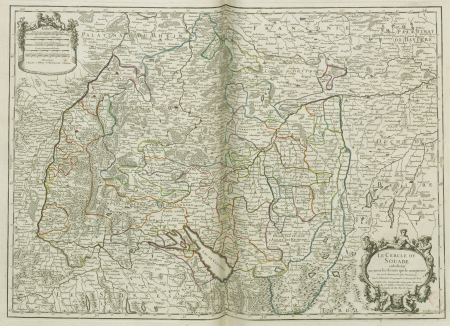
map of the circle of swabia by sanson
bibliothèque nationale de france
maps of the course of the rhine by guillaume sanson
bibliothèque nationale de france
atlas géographique des quatre parties du monde (delisle)
map of scandinavia by guillaume de l'isle (1706)
de groote kaart van amsterdam in 1544 van kornelis antoniszoon... behoorende bij het vijfde deel der geschiedenis van amsterdam - door j. ter gouw, naar het oorspronkelijke gephotographeerd... - btv1b525134777
bibliothèque nationale de france
de groote kaart van amsterdam in 1544 van kornelis antoniszoon... behoorende bij het vijfde deel der geschiedenis van amsterdam - door j. ter gouw, naar het oorspronkelijke gephotographeerd... - btv1b525134777
bibliothèque nationale de france
bibliothèque nationale de france
antoine dewasme-plétinckx
de groote kaart van amsterdam in 1544 van kornelis antoniszoon... behoorende bij het vijfde deel der geschiedenis van amsterdam - door j. ter gouw, naar het oorspronkelijke gephotographeerd... - btv1b525134777
bibliothèque nationale de france
maps of île-de-france by françois de la guillotière
bibliothèque nationale de france
maps of ports and fortresses of the mediterranean by marco boschini (1651)
old maps of heraklion
atlas géographique des quatre parties du monde (delisle)
carte de france by guillaume delisle (1721)
maps of the course of the rhine by guillaume sanson
bibliothèque nationale de france
partie du duché de milan, la principauté de piemont, le montferrat, la république de genes... - hubert jaillot - btv1b53177614j
bibliothèque nationale de france
bibliothèque nationale de france
cartouches by tomas lópez
de groote kaart van amsterdam in 1544 van kornelis antoniszoon... behoorende bij het vijfde deel der geschiedenis van amsterdam - door j. ter gouw, naar het oorspronkelijke gephotographeerd... - btv1b525134777
bibliothèque nationale de france
map of l'evesché du mans by jaillot and cordier
bibliothèque nationale de france
de groote kaart van amsterdam in 1544 van kornelis antoniszoon... behoorende bij het vijfde deel der geschiedenis van amsterdam - door j. ter gouw, naar het oorspronkelijke gephotographeerd... - btv1b525134777
bibliothèque nationale de france
maps of the course of the rhine by guillaume sanson
bibliothèque nationale de france
actinopterygii
animalia
😃 emoji
alphabet
😃 emoji
alphabet
😃 emoji
hands
😃 emoji
alphabet
forbidden
😃 emoji
😃 emoji
man
forbidden
😃 emoji
historical
history
historical
history
historical
history
historical
history
historical
history
illustrations de histoire naturelle - tome i - de seve 1749
baroque
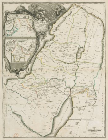
1858 van de velde maps of palestine and jerusalem
eran laor cartographic collection
prints in the united states national library of medicine
polypharmacy
bibliothèque nationale de france
pierre haultin
drawings (print room), leiden university library
ars aemula naturae, leiden university library
illustrations de histoire naturelle - tome i - de seve 1749
baroque
atlas sive cosmographicae (gerardus mercator, 1607)
maps of liège by baptista van doetecum
maps of lisbon by braun & hogenberg (1572)
maps of cascais by braun & hogenberg
a new map of the island of tobago... - by tho.s kitchin... - btv1b53121990k
maps by thomas kitchin
maps of île-de-france by françois de la guillotière
bibliothèque nationale de france
a new map of the island of tobago... - by tho.s kitchin... - btv1b53121990k
maps by thomas kitchin
sanson maps of the holy land
robert cordier (engraver)
veteris novae que urbis amstelodamensis ichnographia, continens publica aedificia ; veterem subnigrioribus... delineata auctore d. stalpaert - btv1b53212660h
bibliothèque nationale de france
maps of campi flegrei by braun & hogenberg
bibliothèque nationale de france
deutzia crenata - botanical illustrations
flora by h. witte (pngs)
description of the nobility of hainaut by braun & hogenberg
context files from gallica
maps of chomutov by braun & hogenberg
maps of čáslav by braun & hogenberg
18th-century maps of corsica
maps by thomas kitchin
bibliothèque nationale de france
sanson maps of the holy land
1858 van de velde maps of palestine and jerusalem
eran laor cartographic collection
1858 van de velde maps of palestine and jerusalem
eran laor cartographic collection
eran laor cartographic collection
hendrik hondius the younger
1858 van de velde maps of palestine and jerusalem
eran laor cartographic collection
1858 van de velde maps of palestine and jerusalem
eran laor cartographic collection
1858 van de velde maps of palestine and jerusalem
eran laor cartographic collection
building
travel
historical
history
historical
history
historical
history
historical
history
historical
history
historical
history
historical
history
maps by john cary
1806 maps of asia
emojione 2.2.7 bw
alphabet
14001 - 14100 of 16,724
Next page
/ 168


![Map of the city of Douai / lith. by F[éli]x Robaut, Félix Robaut, 1846](https://cdn.creazilla.com/illustrations/10000982184/map-of-the-city-of-douai-lith-by-flix-robaut-flix-robaut-1846-md.jpg)


![L'Isle de France. Descrip[tio] of the field of Paris / François de La Hoeye made, 1619](https://cdn.creazilla.com/illustrations/10000573199/l-isle-de-france-descrip-tio-of-the-field-of-paris-fran-ois-de-la-hoeye-made-1619-sm.jpg)


![Czaslavium vulgo Czasla Bohemiae civitas; Commoda vulgo Comethau Bohemiae civitas / Communicavit G. Houfnaglius depictum a filio A[nn]o 1617, 1635](https://cdn.creazilla.com/illustrations/10000386904/czaslavium-vulgo-czasla-bohemiae-civitas-commoda-vulgo-comethau-bohemiae-civitas-communicavit-g-houfnaglius-depictum-a-filio-a-nn-o-1617-1635-sm.jpg)