Log in
All resources
Create a design
Tools
16,724 Free Images of Language
bibliothèque nationale de france
finger
👶 people & body emoji
👌 fingers emoji
hand sign
body language
the comprehensive history of england (1876)
english-language maps showing history
1870s maps showing history
victory
eran laor cartographic collection
gerard valck
the comprehensive history of england (1876)
english-language maps showing history
across the sub-arctics of canada, a journey of 3,200 miles by canoe and snow shoe through the hudson bay region (1908)
old maps of canada
maps from the earth and its inhabitants, vol. iv
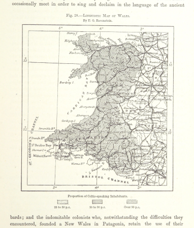
linguistic maps of wales
maps of the battle of the nile
battle of alexandria
the comprehensive history of england (1876)
english-language maps showing history
charles william meredith van de velde
eran laor cartographic collection
the comprehensive history of england (1876)
english-language maps showing history
the comprehensive history of england (1876)
english-language maps showing history
the comprehensive history of england (1876)
danube in 1704
world war i posters in the library of congress
world war i posters of germany
prints (print room), leiden university library
adolf carel nunnink
maps from the earth and its inhabitants, vol. xii
1710s maps of africa
the comprehensive history of england (1876)
english-language maps showing history
😃 emoji
finger
😃 emoji
finger
😃 emoji
hippie
😃 emoji
hippie
male
job
ornament
food
andalusia in the 1590s
1590s maps of spain
william henry toms
henry popple
old maps of plymouth and devonport
16th-century maps of england
😃 emoji
finger
😃 emoji
victory
😃 emoji
victory
😃 emoji
finger
1700s maps of the netherlands
maps by nicolas sanson
la magnifique rotonde des filles s.te marie proche la porte st. antoine . a paris du dessein du sieur mansart - btv1b53181587n
historical images of temple du marais
jean-fréderic phélypeaux
guillaume dheulland
atlas, ou représentation du monde universel et des parties d'icelui, faicte en tables et descriptions très amples et exactes, divisé en deux tomes. édition nouvelle... - btv1b53103889w
maps facing west
maps of ancient israel by philippe de la rué
bibliothèque nationale de france
fossa sanctae mariae quae et eugeniana dicitur vulgo de nieuwe grift - btv1b532255218
maps of venlo by willem and johannes blaeu
die caerte vande zeekusten van biscaien, zeer quade havens voer groote schepen tusschen rio de sella en aviles - lucas io(ann)es aurigarius inve(n)t(or) ; ioannes a doetecum fecit - btv1b531944702
bibliothèque nationale de france
beschrijvinghe der zee custen van engelandt tusschen wicht ende doveren, met die principale havenen ende gedaenten des selven landts - per lucas ioannem aurigarius enchusia ; ioes à doetecu. f. - btv1b53225457t
bibliothèque nationale de france
china veteribus sinarum regio nunc incolis tame dicta
coats of arms on maps
pierre moullart-sanson
guillaume sanson
bibliothèque nationale de france
hendrik de leth
bibliothèque nationale de france
guillaume sanson
china veteribus sinarum regio nunc incolis tame dicta
bibliothèque nationale de france
midle-sex described with the most famous cities of london and westminster (1610)
bibliothèque nationale de france
orae maritimae norvegiae inter bergas et ieddrum, quemadmodum ibi in sua stat figura, quum lidam versus est inde velisicatur, accurata descriptio - lucas ioannes aurigarius inventor ; ioannes à doetecum fecit - btv1b53235848p
bibliothèque nationale de france
die caerte vande zeekusten van biscaien, zeer quade havens voer groote schepen tusschen rio de sella en aviles - lucas io(ann)es aurigarius inve(n)t(or) ; ioannes a doetecum fecit - btv1b531944702
bibliothèque nationale de france
view of mount vesuvius by joris hoefnagel
context files from gallica
caerte vande zee custen van gallissien, van ortugal tot voer bij c. de finisterre, in zyn wesen ende gedaente comende zeijlen uuth de spaensche zee - lucas io(ann)es aurigarius inventor ; ioannes à... - btv1b53194473d
bibliothèque nationale de france
beschrijvinge der zee custen van gallissien beginnende van capo de finisterre tot camino, gemaeckt naet wesen ende gedaente - lucas io(ann)es aurigarius inventor - btv1b53194534k
bibliothèque nationale de france
context files from gallica
lucas janszoon waghenaer
beschrijvinge der zee custen van gallissien beginnende van capo de finisterre tot camino, gemaeckt naet wesen ende gedaente - lucas io(ann)es aurigarius inventor - btv1b53194534k
bibliothèque nationale de france
map of ancient assyria by philippe de la rué
bibliothèque nationale de france
midle-sex described with the most famous cities of london and westminster (1610)
context files from gallica
maps of limousin by jean fayen
gabriel tavernier
die zee custen van biscaijen tusschen laredo ende sentillana soe hem dat selve landt all daer verthoont ennde opdoet - lucas ioannes aurigarius inventor ; ioannes à doetecum fecit - btv1b531945334
1580s maps of spain
orae maritimae norvegiae inter bergas et ieddrum, quemadmodum ibi in sua stat figura, quum lidam versus est inde velisicatur, accurata descriptio - lucas ioannes aurigarius inventor ; ioannes à doetecum fecit - btv1b53235848p
bibliothèque nationale de france
bibliothèque nationale de france
joachim ottens
die zee caerte van portugal; tusschen camino en montego, alsoe dat landt all daer in sijn ghedaente is, met alle sijne haeven enn ondiepten, met groeter naersticheijt en vliedt ghecorrigeert - btv1b531945351
bibliothèque nationale de france
bibliothèque nationale de france
maps by thomas kitchin
de caerte ofte zee custen van pruijssen, met zijne haffen ofte groote rivieren, vander memel off tot heel tho, alsoe tlant aldaer in zijn wesen is - luca ioannis aurigarius aut. ; ioannes à doetecum fecit - btv1b53235794k
bibliothèque nationale de france
context files from gallica
lucas janszoon waghenaer
canalis celebris vel navigationis à bristovio, atque totius situs inter galliam belgicam et britanniam accurata delineatio, eiusdemque terrae verus vultus cum suis miliaribus, ventis ac ascendentibus -... - btv1b53225454g
bibliothèque nationale de france
view of mount vesuvius by joris hoefnagel
context files from gallica
views of nonsuch palace by joris hoefnagel
context files from gallica
de custen van een deel van denemarken ende swedenrijck, beginnende van vuijtste tot calmer toe - lucas ianß wag. inve(n)t(or) ; (ioannes à doetecum fecit) - btv1b53235859j
bibliothèque nationale de france
die zee caerte van portugal; tusschen camino en montego, alsoe dat landt all daer in sijn ghedaente is, met alle sijne haeven enn ondiepten, met groeter naersticheijt en vliedt ghecorrigeert - btv1b531945351
bibliothèque nationale de france
maps of the iberian peninsula by mercator-hondius
maps by pieter van der keere
caerte vande zee custen van gallissien, van ortugal tot voer bij c. de finisterre, in zyn wesen ende gedaente comende zeijlen uuth de spaensche zee - lucas io(ann)es aurigarius inventor ; ioannes à... - btv1b53194473d
bibliothèque nationale de france
beschrijvinge der zee custen van gallissien beginnende van capo de finisterre tot camino, gemaeckt naet wesen ende gedaente - lucas io(ann)es aurigarius inventor - btv1b53194534k
bibliothèque nationale de france
orae maritimae norvegiae inter bergas et ieddrum, quemadmodum ibi in sua stat figura, quum lidam versus est inde velisicatur, accurata descriptio - lucas ioannes aurigarius inventor ; ioannes à doetecum fecit - btv1b53235848p
bibliothèque nationale de france
die custe van lijfflandt, met de eijlanden daer beneffens, also hem dat landt aldaer verthoont ende in zijn ghedaente is, van ekeholmen off tot sijburchs ness tho - lucas ioannis aurigarius inventor... - btv1b532358064
bibliothèque nationale de france
de caerte ofte zee custen van pruijssen, met zijne haffen ofte groote rivieren, vander memel off tot heel tho, alsoe tlant aldaer in zijn wesen is - luca ioannis aurigarius aut. ; ioannes à doetecum fecit - btv1b53235794k
bibliothèque nationale de france
china veteribus sinarum regio nunc incolis tame dicta
bibliothèque nationale de france
china veteribus sinarum regio nunc incolis tame dicta
bibliothèque nationale de france
bibliothèque nationale de france
guillaume sanson
beschrijvinghe der zee custen van engelandt tusschen wicht ende doveren, met die principale havenen ende gedaenten des selven landts - per lucas ioannem aurigarius enchusia ; ioes à doetecu. f. - btv1b53225457t
bibliothèque nationale de france
views of nonsuch palace by joris hoefnagel
context files from gallica
de caerte ofte zee custen van pruijssen, met zijne haffen ofte groote rivieren, vander memel off tot heel tho, alsoe tlant aldaer in zijn wesen is - luca ioannis aurigarius aut. ; ioannes à doetecum fecit - btv1b53235794k
bibliothèque nationale de france
die zee caerte van portugal; tusschen camino en montego, alsoe dat landt all daer in sijn ghedaente is, met alle sijne haeven enn ondiepten, met groeter naersticheijt en vliedt ghecorrigeert - btv1b531945351
bibliothèque nationale de france
maps of wales by humphrey llwyd
maps by pieter van der keere
maps of provence by pierre-jean de bompar
bibliothèque nationale de france
die custe van lijfflandt, met de eijlanden daer beneffens, also hem dat landt aldaer verthoont ende in zijn ghedaente is, van ekeholmen off tot sijburchs ness tho - lucas ioannis aurigarius inventor... - btv1b532358064
bibliothèque nationale de france
caerte vande zee custen van gallissien, van ortugal tot voer bij c. de finisterre, in zyn wesen ende gedaente comende zeijlen uuth de spaensche zee - lucas io(ann)es aurigarius inventor ; ioannes à... - btv1b53194473d
bibliothèque nationale de france
view of mount vesuvius by joris hoefnagel
bibliothèque nationale de france
maps in the rijksmuseum amsterdam
maps by frederick de wit
french-language maps
ambroise tardieu
self-published work
wmf agora icon set
drawings (print room), leiden university library
ars aemula naturae, leiden university library
drawings (print room), leiden university library
ars aemula naturae, leiden university library
male
job
😃 emoji
victory
😃 emoji
victory
😃 emoji
finger
😃 emoji
finger
😃 emoji
victory
maps in the rijksmuseum amsterdam
18th-century maps of japan
map of the circle of westfalia by sanson
louis cordier
françois de la pointe
1620s maps of france
manuscripts from gallica
impressionism
kriegs theater zwischen russland und der ottomanischen pforte... - herausgegeben bey t. mollo in wien - btv1b53119380b
tranquillo mollo
atlas, ou représentation du monde universel et des parties d'icelui, faicte en tables et descriptions très amples et exactes, divisé en deux tomes. édition nouvelle... - btv1b53103889w
17th-century maps of guyana
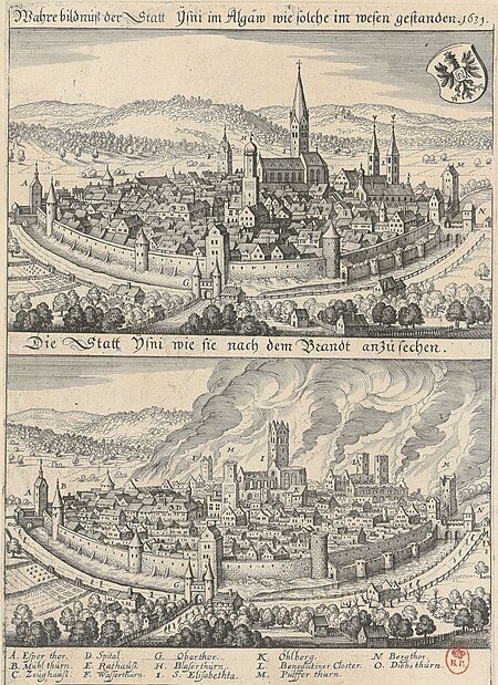
1631 stadtbrand von isny im allgäu
baroque
venezuela cum parte australi novae andalusiae - (willem janszoon blaeu et joan blaeu) - btv1b8596474b
17th-century maps of venezuela
15201 - 15300 of 16,724
Next page
/ 168


![Midle-Sex described with the most famous cities of London and Westminster / Described by Iohn Norden; Augme[n]ted by I. Speed; Jodocus Hondius caelavit, between 1610 and 1616](https://cdn.creazilla.com/illustrations/10001061537/midle-sex-described-with-the-most-famous-cities-of-london-and-westminster-described-by-iohn-norden-augmented-by-i-speed-jodocus-hondius-caelavit-between-1610-and-1616-sm.webp)


![Midle-Sex described with the most famous cities of London and Westminster / Described by Iohn Norden; Augme[n]ted by I. Speed; Jodocus Hondius caelavit, between 1610 and 1616](https://cdn.creazilla.com/illustrations/10001399628/midle-sex-described-with-the-most-famous-cities-of-london-and-westminster-described-by-iohn-norden-augmented-by-i-speed-jodocus-hondius-caelavit-between-1610-and-1616-sm.webp)
![Totius Lemovici et confinium provinciarum quantum ad dioecesin Lemovicensen spectant novissima et fidissima descriptio / Aut[ore] Jo[hanne] Fayano M[edico] L[emovicense]; G[abriel] T[avernier] F[ecit], 1594](https://cdn.creazilla.com/illustrations/10000258251/totius-lemovici-et-confinium-provinciarum-quantum-ad-dioecesin-lemovicensen-spectant-novissima-et-fidissima-descriptio-autore-johanne-fayano-medico-lemovicense-gabriel-tavernier-fecit-1594-md.jpg)


![The Isles of Jersey, Guernsey, Alderney, [et]c: drawn from the best surveys by Tho[ma]s Kitchin Geog[graphe]r, Thomas Kitchin](https://cdn.creazilla.com/illustrations/10001003250/the-isles-of-jersey-guernsey-alderney-et-c-drawn-from-the-best-surveys-by-tho-ma-s-kitchin-geog-graphe-r-thomas-kitchin-sm.jpg)


![Cambriae typus / Auctore Humfredo Lhuydo Denbigiense Cambrobritanno; Petrus Kaerius coela[vit], 1607](https://cdn.creazilla.com/illustrations/10000351350/cambriae-typus-auctore-humfredo-lhuydo-denbigiense-cambrobritanno-petrus-kaerius-coelavit-1607-md.jpg)


![Venezuela cum parte Australia Novae Andalusiae / [Willem Janszoon Blaeu et Joan Blaeu], Joan Blaeu, between 1638 and 1640](https://cdn.creazilla.com/illustrations/10000255596/venezuela-cum-parte-australia-novae-andalusiae-willem-janszoon-blaeu-et-joan-blaeu-joan-blaeu-between-1638-and-1640-sm.webp)