Log in
All resources
Create a design
9,033 Free Images of Latin
bibliothèque nationale de france
america, quarta pars orbis (quam plerunque novum orbem appellitand) primo detecta est anno 1492... - c. visscher, excudit - btv1b7200220t
context files from gallica
maps by willem and johannes blaeu
ateliers bmb mercator
spain in the 1640s
regnorum hispaniae nova descriptio (blaeu)
guillaume sanson
german renaissance
liber chronicarum, rijksmuseum amsterdam
regnorum hispaniae nova descriptio (blaeu)
spain in the 1640s
maps of mexico city by braun & hogenberg
maps of cusco by braun & hogenberg
situs terrae promissionis by christian van adrichom
context files from gallica
serenissimae reipublicae genuensis ducatus et dominii nova descriptio - gio. bat.ta vrints - btv1b53042587g
context files from gallica
maps of enns by braun & hogenberg
bibliothèque nationale de france
description of the nobility of hainaut by braun & hogenberg
bibliothèque nationale de france
maps by willem and johannes blaeu
1630s maps of asia
territorium argentoratense (1652 map)
bibliothèque nationale de france
maps of barbary coast by mercator-hondius
bibliothèque nationale de france
america, quarta pars orbis (quam plerunque novum orbem appellitand) primo detecta est anno 1492... - c. visscher, excudit - btv1b7200220t
bibliothèque nationale de france
stonehenge in art
joan blaeu
situs terrae promissionis by christian van adrichom
bibliothèque nationale de france
arnold van langren map of east africa
bibliothèque nationale de france
regnorum hispaniae nova descriptio (blaeu)
spain in the 1640s
maps of haarlem by braun & hogenberg
bibliothèque nationale de france
regnorum hispaniae nova descriptio (blaeu)
spain in the 1640s
pierre moullart-sanson
guillaume sanson
america, quarta pars orbis (quam plerunque novum orbem appellitand) primo detecta est anno 1492... - c. visscher, excudit - btv1b7200220t
bibliothèque nationale de france
maps of innsbruck by braun & hogenberg
alexandre colyn
maps of gmunden by braun & hogenberg
bibliothèque nationale de france
maps of huy by braun & hogenberg
bibliothèque nationale de france
america, quarta pars orbis (quam plerunque novum orbem appellitand) primo detecta est anno 1492... - c. visscher, excudit - btv1b7200220t
bibliothèque nationale de france
maps of asia by mercator-hondius
ateliers bmb mercator
maps of cornwall and south wales by gerardus mercator
ateliers bmb mercator
maps of africa by mercator-hondius
ateliers bmb mercator
historia naturalis van rudolf ii, t iv
prints by egbert van panderen in the rijksmuseum amsterdam
prints of cartouches in the rijksmuseum amsterdam
prints by simon frisius in the rijksmuseum amsterdam
simon frisius
liber chronicarum, rijksmuseum amsterdam
german renaissance
old maps of bourbonnais
1660s maps of france
maps by hendrik hondius the younger
1632 maps of africa
maps of the peloponnese by gerardus mercator
1640s maps of greece
liber chronicarum, rijksmuseum amsterdam
german renaissance
maps by emanuel bowen
1744 fleurons
johann friedrich walther
1738 in berlin-mitte
maps of alhama de granada by braun & hogenberg
bibliothèque nationale de france
bibliothèque nationale de france
guillaume sanson
america, quarta pars orbis (quam plerunque novum orbem appellitand) primo detecta est anno 1492... - c. visscher, excudit - btv1b7200220t
bibliothèque nationale de france
maps of schwäbisch hall by braun & hogenberg
bibliothèque nationale de france
america, quarta pars orbis (quam plerunque novum orbem appellitand) primo detecta est anno 1492... - c. visscher, excudit - btv1b7200220t
bibliothèque nationale de france
maps by willem and johannes blaeu
17th-century maps of dombes
orbis pictus
maps of barbary coast by mercator-hondius
bibliothèque nationale de france
america, quarta pars orbis (quam plerunque novum orbem appellitand) primo detecta est anno 1492... - c. visscher, excudit - btv1b7200220t
bibliothèque nationale de france
bibliothèque nationale de france
guillaume sanson
maps of formia by braun & hogenberg
bibliothèque nationale de france
maps of rügen by eilhard lubinus
bibliothèque nationale de france
maps of ancient italy by philipp clüver
bibliothèque nationale de france
territorium argentoratense (1652 map)
context files from gallica
maps of dordrecht by braun & hogenberg
bibliothèque nationale de france
maps of münstermaifeld by braun & hogenberg
maps of cochem by braun & hogenberg
regnorum hispaniae nova descriptio (blaeu)
spain in the 1640s
maps of bamberg by braun & hogenberg
bibliothèque nationale de france
regnorum hispaniae nova descriptio (blaeu)
spain in the 1640s
maps of nové zámky by braun & hogenberg
maps of visegrád by braun & hogenberg
descriptio daciarum (17th-century map)
maps by pieter van der keere
america, quarta pars orbis (quam plerunque novum orbem appellitand) primo detecta est anno 1492... - c. visscher, excudit - btv1b7200220t
bibliothèque nationale de france
bibliothèque nationale de france
guillaume sanson
western collection of the chester beatty library
proto-renaissance,gothic art
maps of europe by mercator-hondius
ateliers bmb mercator
maps of north england by gerardus mercator
ateliers bmb mercator
maps of the british isles by gerardus mercator
ateliers bmb mercator
stothard engravings of the bayeux tapestry 1823
maps of alcanerilla by braun & hogenberg
context files from gallica
maps of ancient israel by philippe de la rué
eran laor cartographic collection
pocahontas (after simon van de passe - national portrait gallery, washington)
1616 engravings
eran laor cartographic collection
gerard de jode
simon gribelin
1709 fleurons
liber chronicarum, rijksmuseum amsterdam
german renaissance
architecture
light
book illustrations in the british museum
german renaissance
17th-century maps of the british isles
maps by abraham ortelius
old images of goa
anno salutis
maps of los palacios by braun & hogenberg
maps of las cabezas by braun & hogenberg
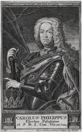
charles iii philip, elector palatine
jacob andreas fridrich
sugar skull
mexico
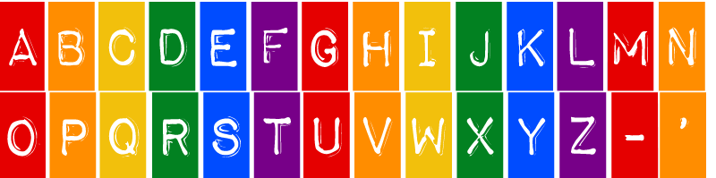
alphabet
a-z
handbook of ornament (1900) illustrations
works of art
prints by jacob matham in the los angeles county museum of art
engravings by hendrick goltzius
dancer
dance
zehn karten und ansichten den schlachtfelden des amerikanischen unabhängigkeitskreiges in den staaten pennsylvanien und new york
maps in the library of congress
civitates orbis terrarum. de praecipuis totius universi urbibus. liber secundus
maps of pozzuoli by braun & hogenberg
zehn karten und ansichten den schlachtfelden des amerikanischen unabhängigkeitskreiges in den staaten pennsylvanien und new york
maps in the library of congress
maps of ancient italy by philipp clüver
maps of ancient sicily
maps of landrecies by braun & hogenberg
maps of beaumont by braun & hogenberg
maps of neuss by braun & hogenberg
maps of bonn by braun & hogenberg
maps of mombasa by braun & hogenberg
maps of aden by braun & hogenberg
flemish baroque painting,baroque
symbola heroica (1682)
civitates orbis terrarum. de praecipuis totius universi urbibus. liber secundus
maps of emmerich by braun & hogenberg
dirk v of holland in engravings
dordracum illustratum
portrait
seneca
high renaissance
pirro ligorio
maps of mombasa by braun & hogenberg
maps of cefala by braun & hogenberg
maps by willem and johannes blaeu
1640s maps of ukraine
maps of neuss by braun & hogenberg
maps of bonn by braun & hogenberg
book illustrations in the british museum
prints by tobias stimmer
maps by willem and johannes blaeu
1663 maps of africa
maps of meldorf by braun & hogenberg
maps of heide by braun & hogenberg
prints in the stadsarchief amsterdam
david jacob van lennep (1774–1853)
limousin (province) in the 17th century
context files from gallica
6501 - 6600 of 9,033
Next page
/ 91


![Huum opp. Condrusorum Caput [...] Anno partae salutis. M. D. LXXIIII., between 1574 and 1640](https://cdn.creazilla.com/illustrations/10001498653/huum-opp-condrusorum-caput-anno-partae-salutis-m-d-lxxiiii-between-1574-and-1640-md.jpg)


![Amoenissimus castri Granatensis, vulgo Alhambre dicti, ab Oriente prospectus / Effigiabat Georgius Hufnagli[us] anno dnj 1564, between 1564 and 1640](https://cdn.creazilla.com/illustrations/10000300894/amoenissimus-castri-granatensis-vulgo-alhambre-dicti-ab-oriente-prospectus-effigiabat-georgius-hufnaglius-anno-dnj-1564-between-1564-and-1640-md.jpg)


![Owar, germanice Nieuhuisel; Vizzegrad, germanice Plindeburg / Communicavit G. Houfnaglius depict. a filio a[nn]o 1595, between 1595 and 1640](https://cdn.creazilla.com/illustrations/10001244849/owar-germanice-nieuhuisel-vizzegrad-germanice-plindeburg-communicavit-g-houfnaglius-depict-a-filio-anno-1595-between-1595-and-1640-md.jpg)


![[Ten maps and views of the battlefields of the American Revolutionary War in the states of Pennsylvania and New York], 1777](https://cdn.creazilla.com/illustrations/10001017179/ten-maps-and-views-of-the-battlefields-of-the-american-revolutionary-war-in-the-states-of-pennsylvania-and-new-york-1777-md.jpg)

![[Ten maps and views of the battlefields of the American Revolutionary War in the states of Pennsylvania and New York], 1777](https://cdn.creazilla.com/illustrations/10001017178/ten-maps-and-views-of-the-battlefields-of-the-american-revolutionary-war-in-the-states-of-pennsylvania-and-new-york-1777-sm.webp)
![Siciliae antiquae descriptio. 15; Corsicae antiquae descriptio. 16; Sardiniae antiquae descriptio / auctore Phil[ippo] Cluverio; Henry le Roy fecit, 1624](https://cdn.creazilla.com/illustrations/10001349357/siciliae-antiquae-descriptio-15-corsicae-antiquae-descriptio-16-sardiniae-antiquae-descriptio-auctore-phil-ippo-cluverio-henry-le-roy-fecit-1624-sm.jpg)


![Novesium vulgo Neus [...]; Verona, nunc Bonna [...]; Brula, vulgari idiomate Broell ante bellum; Sontina, Zunss Oppidum ad Rheni ripas [...], 1635](https://cdn.creazilla.com/illustrations/10000945882/novesium-vulgo-neus-verona-nunc-bonna-brula-vulgari-idiomate-broell-ante-bellum-sontina-zunss-oppidum-ad-rheni-ripas-1635-md.jpg)

![Aethiopia inferior, vel exterior, partes magis septentrionales, quae hic desiderantur, vide in tabula Aethiopiae superioris / [Joan Blaeu], 1663](https://cdn.creazilla.com/illustrations/10000599277/aethiopia-inferior-vel-exterior-partes-magis-septentrionales-quae-hic-desiderantur-vide-in-tabula-aethiopiae-superioris-joan-blaeu-1663-sm.jpg)

