Log in
All resources
Create a design
49,962 Free Images of Maps
truscott map of st-petersburg 1753
ivan sokolov
flag
eran laor cartographic collection
bibliothèque nationale de france
french-language maps
usa
patriotic
gemeente atlas van nederland - south holland
1860s maps of south holland
maps
flag
maps
flag
gemeente atlas van nederland - south holland
maps of groot-ammers
maps of paris by braun & hogenberg
maps of paris from paris musées
atlas maior, vol 4 (netherlands) - joan blaeu, 1667 - bl 114.h(star).4
1667 maps
feather pack
maps
feathericon pack
maps
mono pack
maps
zondicons pack
maps
chicago and the midwest, newberry library
illinois & michigan canal
maps
flag
1803 in berlin
1803 maps
old maps of virginia
p.s. duval & son
the story of mexico (1889 book)
1880s maps of mexico
topographia braunschweig lüneburg (merian)
baroque
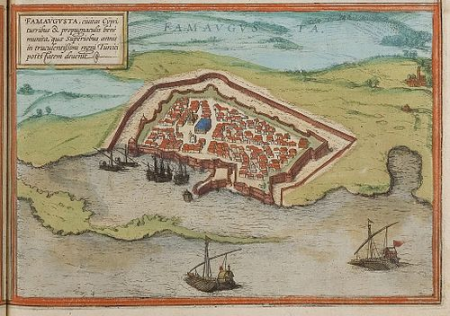
maps of famagusta by braun & hogenberg
list of cities with defensive walls
old maps of regions of poland
starachowice
eran laor cartographic collection
engravings by frans hogenberg
nicolaas samuel crucquius
old maps of delfland
eran laor cartographic collection
tranquillo mollo
maps in the library of congress
1785 maps
maps by macdonald gill
royal mail
maps
flag
maps
flag
maps
flag
maps
flag
character
maps
maps
flag
maps
flag
maps
flag
maps
flag
maps
flag
poland
lgbt
hungary
lgbt
west seram regency
johannes nessel
old maps of the dutch east india company
1705
eran laor cartographic collection
pierre françois tardieu
old maps of hindeloopen
baroque
maps of hamburg by braun & hogenberg
maps of hamburg-altstadt
truscott map of st-petersburg 1753
ivan sokolov
truscott map of st-petersburg 1753
ivan sokolov
truscott map of st-petersburg 1753
ivan sokolov
truscott map of st-petersburg 1753
ivan sokolov
truscott map of st-petersburg 1753
ivan sokolov
maps by christian sgrothen
old maps of zeeland
propaganda map
truscott map of st-petersburg 1753
ivan sokolov
17th-century maps of saxony
1690s maps of saxony
maps of ghent by hendrik hondius
19th-century maps of the malay archipelago
the cruise of the marchesa (1889)
lordship of mechelen
1645 maps of belgium
eran laor cartographic collection
joseph franz kaiser
eran laor cartographic collection
sanson maps of asia
the comprehensive history of england (1876)
english-language maps showing history
1910 maps of hamburg
emery walker
gemeente atlas van nederland - south holland
old maps of gouda
maps of south america by mercator-hondius
maps in the biblioteca nacional do brasil
gemeente atlas van nederland - south holland
old maps of gouda
old maps of the london borough of southwark
john rocque's 1746 map of london
maps of mombasa by braun & hogenberg
maps of cefala by braun & hogenberg
maps by pieter van der keere
maps by abraham ortelius
maps from the earth and its inhabitants, vol. xv
19th-century maps of british columbia
maps from the earth and its inhabitants, vol. iv
topographic maps of ireland
maps from the earth and its inhabitants, vol. xii
19th-century maps of senegal
maps from the earth and its inhabitants, vol. xv
19th-century maps of british columbia
1677 maps of asia
georg widmann
maps of antwerp city walls
old maps of antwerp
maps showing 19th-century history
isaiah thomas (publisher)
maps made in the 17th century
johannes van keulen
eran laor cartographic collection
cornelis de bruyn
truscott map of st-petersburg 1753
ivan sokolov
truscott map of st-petersburg 1753
ivan sokolov
maps of liège by johannes blaeu - derivative files
église saint-remacle (liège)
truscott map of st-petersburg 1753
ivan sokolov
truscott map of st-petersburg 1753
ivan sokolov
truscott map of st-petersburg 1753
ivan sokolov
truscott map of st-petersburg 1753
ivan sokolov
truscott map of st-petersburg 1753
ivan sokolov
maps by christian sgrothen
old maps of zeeland
truscott map of st-petersburg 1753
ivan sokolov
maps by willem and johannes blaeu
old maps of delft
german-language maps of the balkans
1910s maps of albania
maps from the mechanical curator collection
australia (1873) by booth
maps from the mechanical curator collection
australia (1873) by booth
english-language maps
maps by john cary
old maps of china in harvard map collection
1749 maps of asia
maps of hamburg-altstadt
1588 maps of hamburg
1880s maps of tunisia
maps from gallica
maps by tomas lopez
1785 maps of africa
maps of the land of oz
1914 maps
1794 rocque wall map of ireland
county clare
19th-century portrait paintings in the musée national du château de versailles
jean charles nicaise perrin
maps showing 19th-century history
1812 maps of africa
drawings in the museu antônio parreiras
graphite
old maps of ghent by jacques horenbault
old maps of sint-elisabethbegijnhof
a map of the provinces of new york and new jersey, with a part of pennsylvania and the province of quebec
lawrence h. slaughter collection of english maps, charts, globes, books and atlases
a map of the provinces of new york and new jersey, with a part of pennsylvania and the province of quebec
lawrence h. slaughter collection of english maps, charts, globes, books and atlases
a map of the provinces of new york and new jersey, with a part of pennsylvania and the province of quebec
lawrence h. slaughter collection of english maps, charts, globes, books and atlases
maps from the earth and its inhabitants, vol. xiii
maps of weather and climate of south africa
maps from the earth and its inhabitants, vol. iv
topographic maps of the united kingdom
19801 - 19900 of 49,962
Next page
/ 500


![[Map of the castellania of Gent], Joan Blaeu, 1667](https://cdn.creazilla.com/illustrations/10000630608/map-of-the-castellania-of-gent-joan-blaeu-1667-sm.webp)