Log in
All resources
Create a design
8,995 Free Images of Scale
bibliothèque nationale de france
marco boschini
maps of the islands of greece by marco boschini (1658)
context files from gallica
maps of ports and fortresses of the mediterranean by marco boschini (1651)
map collection of leibniz-institut für länderkunde
guillaume sanson
smithsonian libraries
tranquillo mollo
atlas géographique des quatre parties du monde (delisle)
chorographia britanniae (1741-1742)
bibliothèque nationale de france
maps of the islands of greece by marco boschini (1658)
old maps of psarà
maps of the islands of greece by marco boschini (1658)
context files from gallica
maps of formia by braun & hogenberg
bibliothèque nationale de france
gigapixel examples
checkflicr2
maps from the earth and its inhabitants, vol. vi
shchurovsky glacier
maps from the earth and its inhabitants, vol. vi
shchurovsky glacier
grenzkarte der preussischen, russischen und oestreichischen monarchien (1796)
maps of polotsk governorate
grenzkarte der preussischen, russischen und oestreichischen monarchien (1796)
title pages
map collection of leibniz-institut für länderkunde
maps of portugal by fernando álvares seco
grenzkarte der preussischen, russischen und oestreichischen monarchien (1796)
maps of polotsk governorate
old maps of the tyrol
south tyrol
maps of the islands of greece by marco boschini (1658)
history of milos
old maps of milos
maps facing east
maps of bordeaux by braun & hogenberg
maps of nîmes by braun & hogenberg
old maps of the tyrol
south tyrol
maps of the islands of greece by marco boschini (1658)
history of nisyros
maps of the islands of greece by marco boschini (1658)
history of mykonos
maps of ports and fortresses of the mediterranean by marco boschini (1651)
bibliothèque nationale de france
maps of ports and fortresses of the mediterranean by marco boschini (1651)
bibliothèque nationale de france
maps of ports and fortresses of the mediterranean by marco boschini (1651)
bibliothèque nationale de france
atlas géographique des quatre parties du monde (delisle)
map of europe by guillaume delisle (1700)
atlas géographique des quatre parties du monde (delisle)
french-language title pages
maps of ports and fortresses of the mediterranean by marco boschini (1651)
bibliothèque nationale de france
bibliothèque nationale de france
guillaume sanson
maps of the islands of greece by marco boschini (1658)
old maps of kinaros and levitha
maps of ports and fortresses of the mediterranean by marco boschini (1651)
old maps of kythira
maps of ports and fortresses of the mediterranean by marco boschini (1651)
bibliothèque nationale de france
maps of ports and fortresses of the mediterranean by marco boschini (1651)
bibliothèque nationale de france
maps of ports and fortresses of the mediterranean by marco boschini (1651)
bibliothèque nationale de france
maps of ports and fortresses of the mediterranean by marco boschini (1651)
bibliothèque nationale de france
bibliothèque nationale de france
guillaume sanson
abbildung des ohrts iringen und wie selbiger von georg fridrichen margrafen zu baden verschantzet worden, anno 1621 - btv1b53238701j
baroque
maps of ports and fortresses of the mediterranean by marco boschini (1651)
bibliothèque nationale de france
maps of ports and fortresses of the mediterranean by marco boschini (1651)
bibliothèque nationale de france
maps of ports and fortresses of the mediterranean by marco boschini (1651)
bibliothèque nationale de france
les duchés de cleves, juliers, limbourg (etc.) by jaillot
bibliothèque nationale de france
les duchés de cleves, juliers, limbourg (etc.) by jaillot
bibliothèque nationale de france
balanced scales of justice
svg
alay mountains
alay district
gigapixel examples
checkflicr2
gigapixel examples
checkflicr2
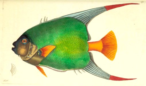
the naturalist's miscellany - george shaw
checkflicr2
vasily surikov
realism
engravings by romeyn de hooghe
parc d’enghien in art
old maps of montenegro
old maps of dubrovnik
tsuga canadensis (illustrations)
a guide to the trees
maps of the islands of greece by marco boschini (1658)
context files from gallica
old maps of the tyrol
south tyrol
maps of the islands of greece by marco boschini (1658)
history of kythnos
maps of meldorf by braun & hogenberg
maps of heide by braun & hogenberg
maps of the islands of greece by marco boschini (1658)
history of kalymnos
maps of the islands of greece by marco boschini (1658)
history of patmos
maps of the islands of greece by marco boschini (1658)
history of naxos
maps of the islands of greece by marco boschini (1658)
history of paros
maps of the islands of greece by marco boschini (1658)
context files from gallica
wikipedia portal icons
scale icons
maps of ports and fortresses of the mediterranean by marco boschini (1651)
bibliothèque nationale de france
bibliothèque nationale de france
guillaume sanson
maps of ports and fortresses of the mediterranean by marco boschini (1651)
bibliothèque nationale de france
bibliothèque nationale de france
1698 map of evesché de meaux
atlas géographique des quatre parties du monde (delisle)
folded maps
atlas géographique des quatre parties du monde (delisle)
18th-century maps of africa
sanson maps of the circles of germany
bibliothèque nationale de france
atlas géographique des quatre parties du monde (delisle)
maps of paris by guillaume delisle
bibliothèque nationale de france
félix robaut
maps of ports and fortresses of the mediterranean by marco boschini (1651)
bibliothèque nationale de france
bibliothèque nationale de france
guillaume sanson
bibliothèque nationale de france
guillaume sanson
atlas géographique des quatre parties du monde (delisle)
map of italy by guillaume delisle (1700)
eagle
cross
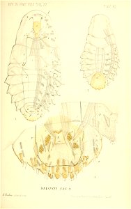
smithsonian libraries
scale insects
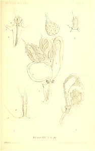
smithsonian libraries
scale insects
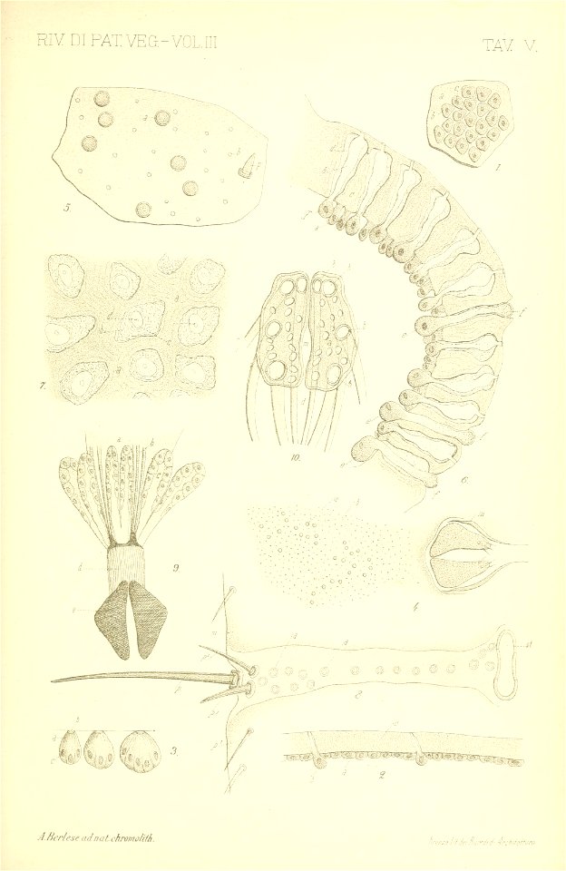
smithsonian libraries
scale insects
smithsonian libraries
scale insects
architecture
instagram
captioned scans from das ständebuch
woodcuts of artisans
grenzkarte der preussischen, russischen und oestreichischen monarchien (1796)
maps of mahilioŭ governorate
grenzkarte der preussischen, russischen und oestreichischen monarchien (1796)
sandomierz voivodeship
skulpturenpark lehmbruck-museum duisburg
expressionism
smithsonian libraries
scale insects
smithsonian libraries
scale insects
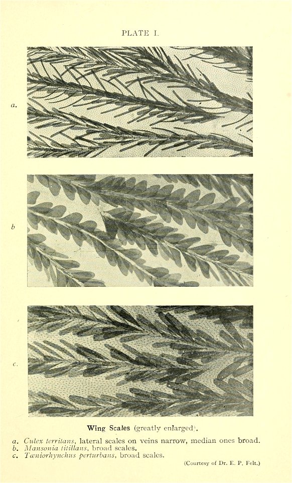
mosquito
insects
maps of peñón de vélez by braun & hogenberg
maps of tunis by braun & hogenberg
1690s maps of greece
maps from gallica
context files from gallica
history of andros
maps of the islands of greece by marco boschini (1658)
history of anafi
context files from gallica
history of amorgos
old hemisphere world maps (partner files)
1800s maps of the world
maps of the islands of greece by marco boschini (1658)
history of ios
map collection of leibniz-institut für länderkunde
1800s maps of the world
old maps of antiparos
old maps of paros
old maps of seville
baroque
maps of the islands of greece by marco boschini (1658)
context files from gallica
maps of the islands of greece by marco boschini (1658)
history of tilos
maps of the islands of greece by marco boschini (1658)
history of leros
bibliothèque nationale de france
guillaume sanson
bibliothèque nationale de france
guillaume sanson
maps of ports and fortresses of the mediterranean by marco boschini (1651)
bibliothèque nationale de france
maps of ports and fortresses of the mediterranean by marco boschini (1651)
bibliothèque nationale de france
5101 - 5200 of 8,995
Next page
/ 90

![A Table of the High Roads through England and Wales.Tab.2. to follow Plate 3 / [Badeslade]; W.H. Toms sculp., 1741](https://cdn.creazilla.com/illustrations/10001464220/a-table-of-the-high-roads-through-england-and-walestab2-to-follow-plate-3-badeslade-wh-toms-sculp-1741-sm.webp)


![Cerigo / [par Marco Boschini], Marco Boschini, 1651](https://cdn.creazilla.com/illustrations/10000847729/cerigo-par-marco-boschini-marco-boschini-1651-sm.jpg)


![Map of Belgium / lith. by F[éli]x Robaut, Félix Robaut, 1841](https://cdn.creazilla.com/illustrations/10001323570/map-of-belgium-lith-by-flix-robaut-flix-robaut-1841-md.jpg)


![Hellas seu Graecia universa apud P[ieter] Mortier, 1690](https://cdn.creazilla.com/illustrations/10001021044/hellas-seu-graecia-universa-apud-pieter-mortier-1690-sm.webp)


