Log in
All resources
Create a design
8,995 Free Images of Scale
bibliothèque nationale de france
marco boschini
maps of the islands of greece by marco boschini (1658)
maps of ports and fortresses of the mediterranean by marco boschini (1651)
atlas géographique des quatre parties du monde (delisle)
guillaume sanson
map collection of leibniz-institut für länderkunde
grenzkarte der preussischen, russischen und oestreichischen monarchien (1796)
carte de france by guillaume delisle (1721)
early netherlandish painting
a topographical map of the county of berks (1761)
bibliothèque nationale de france
maps of the islands of greece by marco boschini (1658)
old maps of mykonos
maps of the islands of greece by marco boschini (1658)
old maps of leros
maps of the islands of greece by marco boschini (1658)
old maps of ios
maps of the islands of greece by marco boschini (1658)
old maps of patmos
maps of the islands of greece by marco boschini (1658)
old maps of naxos
bibliothèque nationale de france
braun/hogenberg dreizehn orte
maps of bourges by braun & hogenberg
maps of orléans by joris hoefnagel
maps of the islands of greece by marco boschini (1658)
old maps of kythnos
maps of mons (hainaut) by braun & hogenberg
maps of arras by braun & hogenberg
old maps of le tréport
maps from gallica
map of the circle of austria by sanson
1700s maps of austria
old maps of the republic of genoa
maps by alexis-hubert jaillot
high tunnel
vegetables
old maps of the northern hemisphere
1800s maps of the world
grenzkarte der preussischen, russischen und oestreichischen monarchien (1796)
old maps of governorates of the russian empire
grenzkarte der preussischen, russischen und oestreichischen monarchien (1796)
18th-century maps of silesia
maps of ports and fortresses of the mediterranean by marco boschini (1651)
old maps of heraklion
atlas géographique des quatre parties du monde (delisle)
map of scandinavia by guillaume de l'isle (1706)
maps of ports and fortresses of the mediterranean by marco boschini (1651)
bibliothèque nationale de france
bibliothèque nationale de france
guillaume sanson
map of the circle of lower saxony by sanson
bibliothèque nationale de france
maps of ports and fortresses of the mediterranean by marco boschini (1651)
bibliothèque nationale de france
bibliothèque nationale de france
ambroise tardieu
maps of the islands of greece by marco boschini (1658)
old maps of chalki
maps of ports and fortresses of the mediterranean by marco boschini (1651)
old maps of gavdos
atlas géographique des quatre parties du monde (delisle)
carte de france by guillaume delisle (1721)
maps of the islands of greece by marco boschini (1658)
old maps of santorini
cartouches by willem and johannes blaeu
people of turkey in art
scenic designs by philippe chaperon
les huguenots
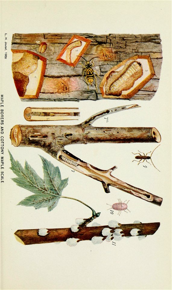
john curtis (entomologist)
entomology
maps of the iberian peninsula by guillaume delisle
1700s maps of the iberian peninsula
maps of the iberian peninsula by guillaume delisle
1700s maps of the iberian peninsula
maps of ports and fortresses of the mediterranean by marco boschini (1651)
old maps of souda (crete)
smithsonian institution libraries
hummingbird
maps of burgos by braun & hogenberg
1645 in spain
plans of the palace and gardens of schönbrunn
baroque
nature
tree
grenzkarte der preussischen, russischen und oestreichischen monarchien (1796)
old maps of galicia (central europe)
carte des régences d'alger by hérisson
bibliothèque nationale de france
le duché de luxembourg divisé en françois, et espagnol dressé sur les mémoires les plus recents - par le sr. sanson - btv1b532139585
guillaume sanson
carte des pays-bas catholiques by guillaume de l'isle (1702)
atlas géographique des quatre parties du monde (delisle)
bibliothèque nationale de france
guillaume sanson
maps of ports and fortresses of the mediterranean by marco boschini (1651)
bibliothèque nationale de france
atlas géographique des quatre parties du monde (delisle)
carte de france by guillaume delisle (1721)
atlas géographique des quatre parties du monde (delisle)
carte de france by guillaume delisle (1721)
maps of agnano and grotta del cane by braun & hogenberg
bibliothèque nationale de france
17th-century maps of slovenia
17th-century maps of istria
georgenhaus leipzig
richard püttner
master of the legend of st. lucy
early netherlandish painting
photos of the moon by lunar orbiter spacecraft
sharonov (lunar crater)
history
bird
maps from the earth and its inhabitants, vol. vi
anzhu islands
paul burman
gigapixel examples
checkflicr2
paintings by marcello bacciarelli in the national museum in warsaw
baroque,classicism
map collection of leibniz-institut für länderkunde
1690s maps of the iberian peninsula
grenzkarte der preussischen, russischen und oestreichischen monarchien (1796)
old maps of galicia (central europe)
master of the legend of st. lucy
early netherlandish painting
master of the legend of st. lucy
early netherlandish painting
1700s maps of rhineland-palatinate
maps of east palatinate by sanson
bibliothèque nationale de france
guillaume sanson
maps of the islands of greece by marco boschini (1658)
context files from gallica
maps of ports and fortresses of the mediterranean by marco boschini (1651)
old maps of souda (crete)
comté de namur . tiré des mémoires les pl. nouveaux par les sr sanson, géographe ordinaire du roy - btv1b532139479
guillaume sanson
bibliothèque nationale de france
guillaume sanson
map of the circle of upper saxony by sanson
bibliothèque nationale de france
maps of ports and fortresses of the mediterranean by marco boschini (1651)
bibliothèque nationale de france
map of the circle of swabia by sanson
bibliothèque nationale de france
atlas géographique des quatre parties du monde (delisle)
map of scandinavia by guillaume de l'isle (1706)
maps of the islands of greece by marco boschini (1658)
old maps of athos
rococo paintings in the gallerie dell'accademia (venice)
paintings of building interiors by michele marieschi
17th-century maps of dorset
maps by john speed
map of the upper rhenian circle by sanson
1680s maps of north rhine-westphalia
ogawa haritsu
pagrus major
paintings of justice
bernard d'agesci
butterfly
brazil
northwestern university chicago campus
postcards of chicago
maps of campi flegrei by braun & hogenberg
bibliothèque nationale de france
17th-century maps of the isle of man
maps by willem and johannes blaeu
maps of lisbon by braun & hogenberg (1572)
maps of cascais by braun & hogenberg
maps of aachen by braun & hogenberg
bibliothèque nationale de france
maps of the islands of greece by marco boschini (1658)
old maps of symi
maps of huy by braun & hogenberg
bibliothèque nationale de france
professions
people
interiors of bains municipaux (strasbourg)
public weight scales in france
historical
history
elliott cresson photo, 1840
maps from the earth and its inhabitants, vol. vi
anzhu islands
angels with balance scales
german renaissance
france in the 1690s
old maps of france
map collection of leibniz-institut für länderkunde
1680s maps of the netherlands
maps of linz by braun & hogenberg
bibliothèque nationale de france
a new map of the island of tobago... - by tho.s kitchin... - btv1b53121990k
maps by thomas kitchin
maps of chomutov by braun & hogenberg
maps of čáslav by braun & hogenberg
description of the nobility of hainaut by braun & hogenberg
context files from gallica
map collection of leibniz-institut für länderkunde
1750s maps of saxony
maps of cambridge by braun & hogenberg
bibliothèque nationale de france
tian shan
alps
maps of the islands of greece by marco boschini (1658)
context files from gallica
5301 - 5400 of 8,995
Next page
/ 90


![Port and Forte[z]za d[ell]a Suda / by Marco Boschini, Marco Boschini, 1651](https://cdn.creazilla.com/illustrations/10001359456/port-and-fortezza-della-suda-by-marco-boschini-marco-boschini-1651-sm.webp)


![Monte Santo / [by Marco Boschini], Marco Boschini, 1658](https://cdn.creazilla.com/illustrations/10001562665/monte-santo-by-marco-boschini-marco-boschini-1658-sm.webp)


![Aquisgranum, vulgo Aich, ad Menapiorum fines [...] Anno partae salutis. M. D. LXXVI. Coloniae Agripp., between 1576 and 1635](https://cdn.creazilla.com/illustrations/10000850330/aquisgranum-vulgo-aich-ad-menapiorum-fines-anno-partae-salutis-m-d-lxxvi-coloniae-agripp-between-1576-and-1635-sm.webp)


![Czaslavium vulgo Czasla Bohemiae civitas; Commoda vulgo Comethau Bohemiae civitas / Communicavit G. Houfnaglius depictum a filio A[nn]o 1617, 1635](https://cdn.creazilla.com/illustrations/10000386904/czaslavium-vulgo-czasla-bohemiae-civitas-commoda-vulgo-comethau-bohemiae-civitas-communicavit-g-houfnaglius-depictum-a-filio-a-nn-o-1617-1635-sm.jpg)


![Isolette [Raclia, Schinussa, etc] / Marco Boschini, 1658](https://cdn.creazilla.com/illustrations/10001438226/isolette-raclia-schinussa-etc-marco-boschini-1658-sm.webp)