Log in
All resources
Create a design
Tools
1,194 Free Images of Sculpting
bibliothèque nationale de france
chorographia britanniae (1741-1742)
paper
historical
pile et face - archives municipales de toulouse
drawings in toulouse
voyages pittoresques et romantiques dans l'ancienne france - toulouse
pile et face - archives municipales de toulouse - archeologie
lithography
print
map of the circle of austria by sanson
1700s maps of austria
flayer
draft
historical images of penang at penang museum
william daniell
black and white photographs of monuments and memorials
adams memorial
statues
usa
oriental scenery (part 5)
ajgaivinath temple
chorographia britanniae (1741-1742)
18th-century maps of cornwall
chorographia britanniae (1741-1742)
18th-century maps of kent
bibliothèque nationale de france
1698 map of evesché de meaux
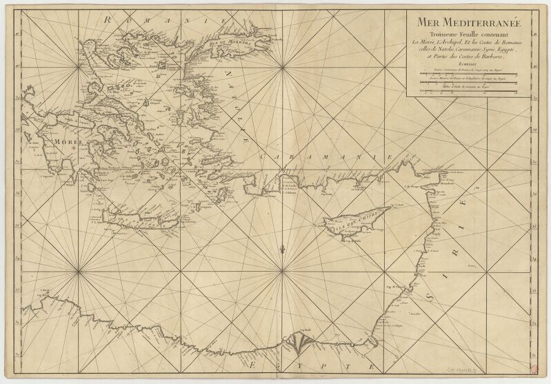
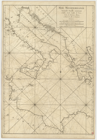
carte de la mer méditerranée en trois feuilles (dheulland et al.)
18th-century maps of the eastern mediterranean
carte de barbarie, nigritie, guinée par guillaume delisle (1707)
bibliothèque nationale de france
carte de la mer méditerranée en trois feuilles (dheulland et al.)
old maps of the central mediterranean
carte de barbarie, nigritie, guinée par guillaume delisle (1707)
bibliothèque nationale de france
carte de barbarie, nigritie, guinée par guillaume delisle (1707)
bibliothèque nationale de france
carte de la mer méditerranée en trois feuilles (dheulland et al.)
18th-century maps of the western mediterranean
carte de la mer méditerranée en trois feuilles (dheulland et al.)
old maps of the central mediterranean
flemish prints in the british museum
baroque
chorographia britanniae (1741-1742)
18th-century maps of monmouthshire
chorographia britanniae (1741-1742)
18th-century maps of middlesex
chorographia britanniae (1741-1742)
18th-century maps of westmorland
william bromley (engraver)
popular graphic arts
flemish prints in the british museum
baroque
18th-century maps of nottinghamshire
chorographia britanniae (1741-1742)
18th-century maps of huntingdonshire
chorographia britanniae (1741-1742)
le lyon de nos pères (vingtrinier, drevet, 1901) from numelyo
le lyon de nos pères (vingtrinier, drevet, 1901)
chorographia britanniae (1741-1742)
18th-century maps of cumberland
chorographia britanniae (1741-1742)
18th-century maps of cambridgeshire
chorographia britanniae (1741-1742)
18th-century maps of lancashire
chorographia britanniae (1741-1742)
18th-century maps of northumberland
broadsheet prints from koninklijke bibliotheek - portraits
broadsheet prints from koninklijke bibliotheek
sagamore hill national historic site
bronze objects
photographs by olof sörling
västerås domkyrka
sculptures of louis philippe i by james pradier
sculptures in the toledo museum of art
historical
history
historical
history
court of neptune fountain
maps from university of amsterdam special collections
atlas der neederlanden
pile et face - archives municipales de toulouse
orientalism
historical
history
18th-century maps of gloucestershire
chorographia britanniae (1741-1742)
chorographia britanniae (1741-1742)
18th-century maps of suffolk
chorographia britanniae (1741-1742)
18th-century maps of warwickshire
chorographia britanniae (1741-1742)
18th-century maps of lincolnshire
chorographia britanniae (1741-1742)
18th-century maps of shropshire
chorographia britanniae (1741-1742)
18th-century maps of leicestershire
chorographia britanniae (1741-1742)
18th-century maps of devon
chorographia britanniae (1741-1742)
18th-century maps of worcestershire
18th-century maps of buckinghamshire
chorographia britanniae (1741-1742)
chorographia britanniae (1741-1742)
old county maps of county durham
chorographia britanniae (1741-1742)
18th-century maps of cheshire
chorographia britanniae (1741-1742)
18th-century maps of rutland
chorographia britanniae (1741-1742)
18th-century maps of surrey
chorographia britanniae (1741-1742)
18th-century maps of somerset
chorographia britanniae (1741-1742)
18th-century maps of berkshire
chorographia britanniae (1741-1742)
18th-century maps of yorkshire
18th-century maps of northamptonshire
chorographia britanniae (1741-1742)
chorographia britanniae (1741-1742)
18th-century maps of bedfordshire
chorographia britanniae (1741-1742)
18th-century maps of dorset
chorographia britanniae (1741-1742)
18th-century maps of hampshire
chorographia britanniae (1741-1742)
18th-century maps of derbyshire
18th-century maps of herefordshire
old county maps of herefordshire
18th-century maps of norfolk, england
chorographia britanniae (1741-1742)
chorographia britanniae (1741-1742)
18th-century maps of staffordshire
chorographia britanniae (1741-1742)
18th-century maps of hertfordshire
school or circle of jan van scorel
donor portraits of couples
historical images of penang at penang museum
william daniell
photographs by olof sörling
västerås domkyrka
sagamore hill national historic site
sculptures in new york (state)
photographs by olof sörling
västerås domkyrka
jean-baptiste-henri delahaye
philippe buache
bibliothèque nationale de france
1698 map of evesché de meaux
carte de barbarie, nigritie, guinée par guillaume delisle (1707)
bibliothèque nationale de france
bibliothèque nationale de france
1698 map of evesché de meaux
bibliothèque nationale de france
sanson map of lorraine
historical
history
art of suriname in the rijksmuseum amsterdam
boats in suriname
19th-century portrait drawings in the rijksmuseum amsterdam
drawings by august allebé in the rijksmuseum amsterdam
david rumsey historical map collection
1790s maps of the holy roman empire
drawings in musée carnavalet
richard phené spiers
pile et face - archives municipales de toulouse
drawings in toulouse
engravings of leopold i of belgium
monument to the dynasty
flayer
draft
pile et face - archives municipales de toulouse
orientalism
studies (drawings) in the rijksmuseum amsterdam
hague school
new york
statues
pile et face - archives municipales de toulouse
drawings in toulouse
pile et face - archives municipales de toulouse
orientalism
models of the statue of freedom (united states capitol)
neoclassicism
health
masks
historical images of loggia del bigallo
cento vedute di firenze antica
flemish prints in the british museum
renaissance
metal
face
map of the upper rhenian circle by sanson
1700s maps of north rhine-westphalia
statue equestre de louis le bien aimé erigée le 14 février 1763 - le charpentier sculpsit ; de seve delinaevit - btv1b53181657s
baroque
sculptures in the rijksmuseum amsterdam
joseph mendes da costa
art of suriname in the rijksmuseum amsterdam
dioramas by gerrit schouten
17th-century portrait paintings of unidentified women
pierre gobert
art of suriname in the rijksmuseum amsterdam
dioramas by gerrit schouten
illustrations from esposizione generale italiana (torino 1884) - not signed
15th-century furniture
new york
usa
901 - 1000 of 1,194
Next page
/ 12


![Map of the Old Land of Diepen Dorst / I. Shutters fecit cum aqua forti; A. Steyaart invenit; I. Stemmers sculpt, Romeyn de Hooghe, [1701]](https://cdn.creazilla.com/illustrations/10001043124/map-of-the-old-land-of-diepen-dorst-i-shutters-fecit-cum-aqua-forti-a-steyaart-invenit-i-stemmers-sculpt-romeyn-de-hooghe-1701-sm.jpg)