Log in
All resources
Create a design
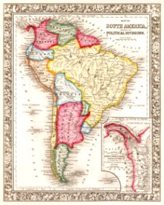
Map of South America, showing its political divisions; Map showing the proposed Atrato-inter-oceanic canalroutes, for connecting the Atlantic and Pacific oceans (1863) by Samuel Augustus Mitchell.
Download
Edit image
Published by:
Creazilla
Author:
New York Public Library
Source:
rawpixel.com
Loading...
1 download
Print it
Copy image
Loading...
maps
brazil
city
south america
world map
poster
peru
amazon
paraguay
vintage maps
poster designs
art poster brazil
MORE LIKE THIS