Log in
All resources
Create a design
Tools
16,724 Free Images of Language
bibliothèque nationale de france
marco boschini
maps of spain by tomas lopez
guillaume sanson
a rapid french course for students in evening classes, private students, and others (1917)
english language
1768 maps of spain
18th-century maps of andalusia
maps of the islands of greece by marco boschini (1658)
context files from gallica
18th-century maps of veneto
1700s maps of slovenia
landais & oberthur
maps from gallica
maps of the kingdom of seville
maps of spain by tomas lopez
maps of the kingdom of córdoba (crown of castile)
maps of spain by tomas lopez
maps of the land of valkenburg
guillaume sanson
maps of the kingdom of seville
maps of spain by tomas lopez
maps of the land of valkenburg
guillaume sanson
maps of the kingdom of seville
maps of spain by tomas lopez
maps of the kingdom of seville
maps of spain by tomas lopez
map of the upper rhenian circle by sanson
maps by nicolas sanson
robert cordier (engraver)
maps by guillaume sanson
robert clive, 1st baron clive in art
j. r. skelton
sanson maps of north america
maps by nicolas sanson
pierre alexander tardieu
delaval (surname)
guillaume sanson
1674 maps
1670s maps of the iberian peninsula
georg widmann
map of the upper rhenian circle by sanson
maps by nicolas sanson
history
time
maps by willem and johannes blaeu
1638 maps of asia
medieval fashion
alois greil
victor levasseur - maps of france
1847 maps
géographie générale; physique, politique et économique (1876)
1870s maps of australia
tipu sultan in art
j. r. skelton
charles william meredith van de velde
eran laor cartographic collection
1891 maps of austria-hungary
maps from gallica
posters in the cooper hewitt, smithsonian design museum
1920 posters of russia
military
army
a rapid french course for students in evening classes, private students, and others (1917)
a rapid french course for students in evening classes, private students, and others (1917)
avant l'opération (1887 painting)
celebrities
military
military
travel
old maps of the region of murcia
maps of spain by tomas lopez
maps of the islands of greece by marco boschini (1658)
history of kythira
sanson maps of the netherlands
1680s maps of the netherlands
maps of the islands of greece by marco boschini (1658)
agathonisi
old maps of farmakonisi
old maps of agathonisi
context files from gallica
history of santorini
maps by jean-baptiste bourguignon d'anville
1727 maps of africa
maps of the islands of greece by marco boschini (1658)
history of the sporades
19th-century maps of andalusia
mapa general de españa (1802)
old maps of asturias
1777 maps of spain
1760s maps of the americas
1760 maps
english-language books about london
old maps of the city of london
french-language maps of south africa
1876 maps of africa
eran laor cartographic collection
claes jansz. visscher (ii)
maps of alcanerilla by braun & hogenberg
context files from gallica
maps of ancient israel by philippe de la rué
eran laor cartographic collection
1750s maps of the netherlands
18th-century maps of zeeland
old maps of katwijk, south holland
brittenburg
17th-century maps of dordogne
philippe de la rué
landais & oberthur
maps from gallica
la rioja (spain) in the 18th century
old maps of la rioja (spain)
atlas géographique des quatre parties du monde (delisle)
18th-century maps of the iberian peninsula
maps of spain by tomas lopez
old maps of guadeloupe
daniel de la feuille
1706 maps of italy
english-language books about london
crosby hall
our empire story by h. e. marshall
j. r. skelton
john williams (missionary)
1837 books
illustrations by warwick goble
indian myth and legend (1913)
elephant riding in art of india
illustrations by warwick goble
electronics
technology
typography
music
typography
music
ribbon
blue
ribbon
blue
ornament
wine
symbol
finger
ornament
heart
ornament
heart
spain
flag
teaching illustrations for language learning
black and white icons
a rapid french course for students in evening classes, private students, and others (1917)
a rapid french course for students in evening classes, private students, and others (1917)
a rapid french course for students in evening classes, private students, and others (1917)
the history and antiquities of london, westminster, southwark and parts adjacent
english-language books about london
henry william bunbury
the gout (gillray)
a rapid french course for students in evening classes, private students, and others (1917)
spanish-language maps
1785 maps
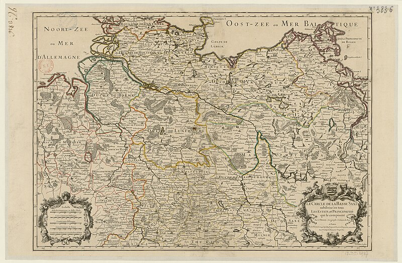
map of the circle of lower saxony by sanson
bibliothèque nationale de france
maps of ports and fortresses of the mediterranean by marco boschini (1651)
bibliothèque nationale de france
sanson map of the german empire (17th century)
sanson maps of the circles of germany
atlas géographique des quatre parties du monde (delisle)
18th-century maps of france
maps of ports and fortresses of the mediterranean by marco boschini (1651)
bibliothèque nationale de france
alsace-lorraine. carte départementale. moselle, meurthe, bas-rhin, haut-rhin - btv1b85935488
bibliothèque nationale de france
maps of ports and fortresses of the mediterranean by marco boschini (1651)
old maps of kythira
bibliothèque nationale de france
guillaume sanson
general charte der in den herzoglich bremen - und verdenschen aemtern und gerichten ottersberg, osterholtz, lilienthal, bremervörde, rotenburg und achim belegenen mööre, und der seit 1750 darin... - btv1b531196435
bibliothèque nationale de france
partie méridionale des estats de savoye ou sont le duché de savoye - par le sr sanson d'abbeville - btv1b530430656
guillaume sanson
bibliothèque nationale de france
guillaume sanson
atlas géographique des quatre parties du monde (delisle)
folded maps
abbildung des ohrts iringen und wie selbiger von georg fridrichen margrafen zu baden verschantzet worden, anno 1621 - btv1b53238701j
baroque
maps of ports and fortresses of the mediterranean by marco boschini (1651)
bibliothèque nationale de france
alsace-lorraine. carte départementale. moselle, meurthe, bas-rhin, haut-rhin - btv1b85935488
bibliothèque nationale de france
bibliothèque nationale de france
cartouches by tomas lópez
carte de la mer méditerranée en trois feuilles (dheulland et al.)
18th-century maps of the western mediterranean
johannes leupenius
jacobus robijn
carte de l'alsace by sanson (1703)
bibliothèque nationale de france
maps of ports and fortresses of the mediterranean by marco boschini (1651)
bibliothèque nationale de france
13401 - 13500 of 16,724
Next page
/ 168


![Map of the department of Ille & Vilaine / published [...] by Landais & Oberthur, lithographers; with the assistance of Mr. G. Corbe, chief road agent of the dept., 1847](https://cdn.creazilla.com/illustrations/10000314825/map-of-the-department-of-ille-vilaine-published-by-landais-oberthur-lithographers-with-the-assistance-of-mr-g-corbe-chief-road-agent-of-the-dept-1847-sm.webp)


![Topographic map of the south-western slope of Menez-haut / surveyed and drawn up [...] by AM Kamelin, 1849](https://cdn.creazilla.com/illustrations/10001387383/topographic-map-of-the-south-western-slope-of-menez-haut-surveyed-and-drawn-up-by-am-kamelin-1849-sm.webp)


![Cerigo / [par Marco Boschini], Marco Boschini, 1651](https://cdn.creazilla.com/illustrations/10000847729/cerigo-par-marco-boschini-marco-boschini-1651-sm.jpg)


