Log in
All resources
Create a design
Tools
16,724 Free Images of Language
bibliothèque nationale de france
history
historical
cc-zero
images from anefo
images from nationaal archief
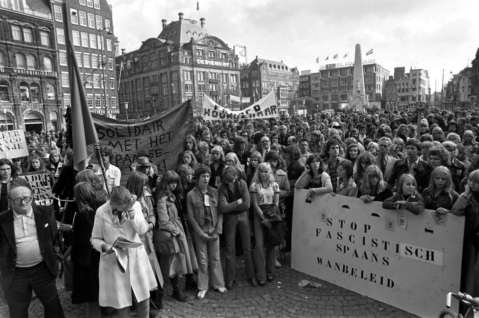
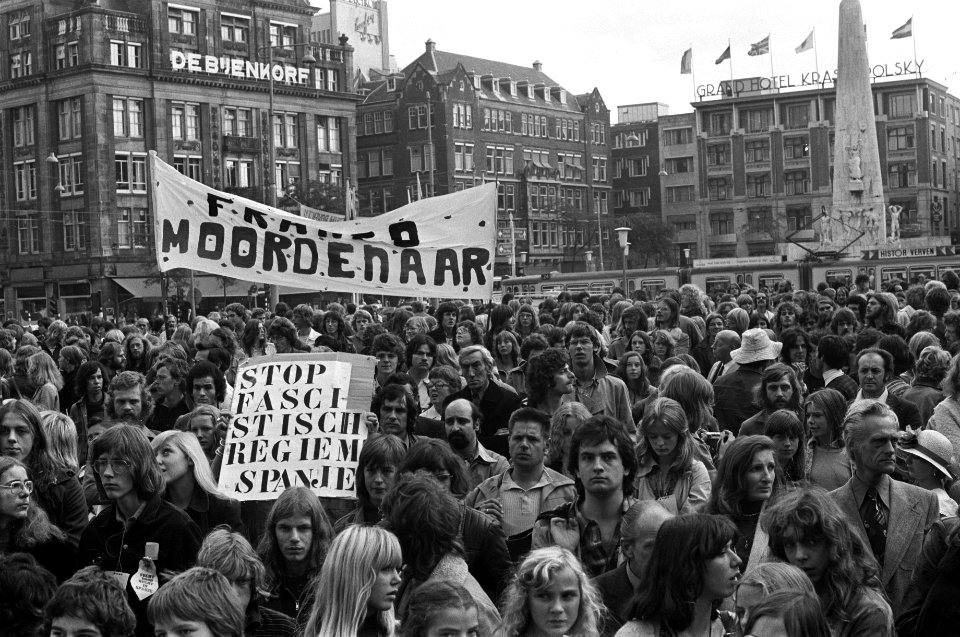
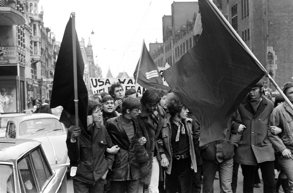
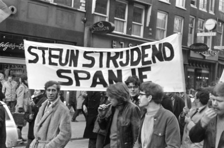
black and white photographs of demonstrations
dutch-language signage at demonstrations
finger
hand sign
historical
history
historical
history
historical
history
historical
history
red cross on stamps
semeuse on stamps
drawings (print room), leiden university library
ars aemula naturae, leiden university library
drawings (print room), leiden university library
ars aemula naturae, leiden university library
juan francisco leonardo (1687) mapa del arzobispado de toledo
1680s maps of spain
brochure
draft
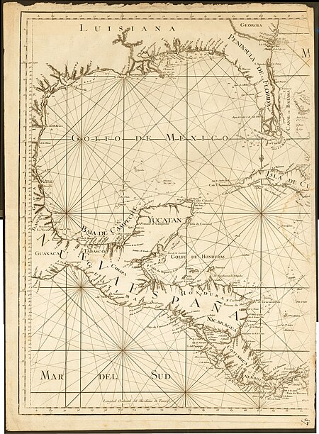
1849 maps of north america
old maps of canada
myths of the hindus & buddhists illustrations
paintings by kshitindranath mazumdar
old maps of vermandois
old maps of santerre
18th-century maps of the black sea
maps by louis brion de la tour
old maps of bologna
gregorio monari
18th-century maps of the aegean sea
jean-fréderic phélypeaux
😃 emoji
hippie
😃 emoji
hippie
globe
world
amérique méridionale (1748, d'anville)
rococo
17th-century maps of cambridgeshire
old county maps of cambridgeshire
paintings in the national army museum, london
tilly kettle
de zee kuste vant landt te noortoosten sorterende onder norweghen ende eendeels onder sweden alsoe tlandt aldaer in zijn gedaente is, van distelberch tot waersberghe - per lucam ioannis aurigariu enchusianu... - btv1b53235851z
bibliothèque nationale de france
map of ancient armenia by philippe de la rué
bibliothèque nationale de france
de zee kuste vant landt te noortoosten sorterende onder norweghen ende eendeels onder sweden alsoe tlandt aldaer in zijn gedaente is, van distelberch tot waersberghe - per lucam ioannis aurigariu enchusianu... - btv1b53235851z
bibliothèque nationale de france
caerte der noordt custe van engelandt, beginnende van robinhodes baij tot cocket eijlandt, alsoe tzelve landt aldaer in zijn gedaente is. - doer lucas iansz wagenaer van enchuijsen ; ioannes à doetecum fecit - btv1b532254620
bibliothèque nationale de france
beschrijvinghe van de zee custen van vlanderen, ende picardien, beghijnnende van nijeupoort tot diepen, met de vlaemsche bancken, begrepen de engte tusschen engelandt ende vranckrijk, twelckmen de hooffden... - btv1b53211568c
bibliothèque nationale de france
de custe van noorweghen, met dat landt van noordt oosten in zijne wesen ende gedaente soe hem dat verthoont ende op doet van mardou tot akersondt - (lucas ioannes aurigarius inventor) ; io(ann)es à... - btv1b53235850h
bibliothèque nationale de france
caerte vande zee custen van arcason ende biscaien met heure havenen ende opdoeninghe van landen ende geberchten - doer lucas iansz wagenaer ; ioannes à doetecum f. - btv1b53156734s
bibliothèque nationale de france
mappa fluminis dicti vulgo beldt, cum omnibus littoralibus oris, limitibus, situsque terrarum vulgo dictarum lalandiae usque ad stephani caput - lucas ioanß wagenaer inventor ; ioannes à doetecum fecit - btv1b53235834g
bibliothèque nationale de france
caerte der noordt custe van engelandt, beginnende van robinhodes baij tot cocket eijlandt, alsoe tzelve landt aldaer in zijn gedaente is. - doer lucas iansz wagenaer van enchuijsen ; ioannes à doetecum fecit - btv1b532254620
bibliothèque nationale de france
het uuterste ofte oosterste deel van de oster zee, beslooten tegens ruslandt lijfflandt, oost finlandt, in welcken de twe opperste ofte veerste laetplaetsen sijn van de geheele oosterse navigatie, te weeten... - btv1b53235861c
old maps of the gulf of finland
views of gerena and san juan by joris hoefnagel
bibliothèque nationale de france
caerte der noordt custe van engelandt, beginnende van robinhodes baij tot cocket eijlandt, alsoe tzelve landt aldaer in zijn gedaente is. - doer lucas iansz wagenaer van enchuijsen ; ioannes à doetecum fecit - btv1b532254620
bibliothèque nationale de france
het uuterste ofte oosterste deel van de oster zee, beslooten tegens ruslandt lijfflandt, oost finlandt, in welcken de twe opperste ofte veerste laetplaetsen sijn van de geheele oosterse navigatie, te weeten... - btv1b53235861c
bibliothèque nationale de france
bibliothèque nationale de france
hendrik de leth
1640s maps of ireland
baroque
de custe van noorweghen, met dat landt van noordt oosten in zijne wesen ende gedaente soe hem dat verthoont ende op doet van mardou tot akersondt - (lucas ioannes aurigarius inventor) ; io(ann)es à... - btv1b53235850h
bibliothèque nationale de france
beschrijvinge vande vermaerde stroemen, t vlie ende t maersdiep ; opstreckende inde zuijder zee voer bij enchuijsen tot amstelredam, met alle de sanden plaeten ende ondiepten op de selve stroemen gheleghen... - btv1b532255737
bibliothèque nationale de france
bibliothèque nationale de france
maps by thomas kitchin
beschrijvinge vande vermaerde stroemen, t vlie ende t maersdiep ; opstreckende inde zuijder zee voer bij enchuijsen tot amstelredam, met alle de sanden plaeten ende ondiepten op de selve stroemen gheleghen... - btv1b532255737
bibliothèque nationale de france
brabantia ducatus - tabula ducatus brabantiae continens marchionatum sacri impery et dominium mechliniense - magna cura edita a petri verbist - btv1b53042443n
bibliothèque nationale de france
het uuterste ofte oosterste deel van de oster zee, beslooten tegens ruslandt lijfflandt, oost finlandt, in welcken de twe opperste ofte veerste laetplaetsen sijn van de geheele oosterse navigatie, te weeten... - btv1b53235861c
bibliothèque nationale de france
symbol
finger
beschrijvinghe van de zee custen van vlanderen, ende picardien, beghijnnende van nijeupoort tot diepen, met de vlaemsche bancken, begrepen de engte tusschen engelandt ende vranckrijk, twelckmen de hooffden... - btv1b53211568c
bibliothèque nationale de france
1630s maps of the americas
maps by jodocus hondius ii
john rocque's 1748 map of london and adjacent country
bibliothèque nationale de france
brabantia ducatus - tabula ducatus brabantiae continens marchionatum sacri impery et dominium mechliniense - magna cura edita a petri verbist - btv1b53042443n
bibliothèque nationale de france
zee caerte vande custe van lijfflant begrepen rontsomme de grooten inham vande rijgsche zee, soe tselfde hem verthoont ende op doet - luca ioannis aurigarius autore ; ioannes à doetecum fecit - btv1b53235807k
bibliothèque nationale de france
zee caerte vande noordt custe van engelandt, alsoe tzelffde landt aldaer in sijn gedaente ende wesen is, met alle sijnn undieptenn - lucas io(ann)es aurigarius inventor ; ioannes à doetecum fecit - btv1b532254603
bibliothèque nationale de france
views of gerena and san juan by joris hoefnagel
context files from gallica
caerte vande zee custen van arcason ende biscaien met heure havenen ende opdoeninghe van landen ende geberchten - doer lucas iansz wagenaer ; ioannes à doetecum f. - btv1b53156734s
bibliothèque nationale de france
maps of ancient israel by philippe de la rué
jean pruthenus somer
bibliothèque nationale de france
guillaume sanson
de zee kuste vant landt te noortoosten sorterende onder norweghen ende eendeels onder sweden alsoe tlandt aldaer in zijn gedaente is, van distelberch tot waersberghe - per lucam ioannis aurigariu enchusianu... - btv1b53235851z
bibliothèque nationale de france
brabantia ducatus - tabula ducatus brabantiae continens marchionatum sacri impery et dominium mechliniense - magna cura edita a petri verbist - btv1b53042443n
bibliothèque nationale de france
john rocque's 1748 map of london and adjacent country
bibliothèque nationale de france
john rocque's 1748 map of london and adjacent country
remigius parr
beschrijvinghe van de zee custen van vlanderen, ende picardien, beghijnnende van nijeupoort tot diepen, met de vlaemsche bancken, begrepen de engte tusschen engelandt ende vranckrijk, twelckmen de hooffden... - btv1b53211568c
bibliothèque nationale de france
1890 posters of france
miss helyett
istanbul in the 1750s
maps by john rocque
john rocque's 1748 map of london and adjacent country
bibliothèque nationale de france
bibliothèque nationale de france
guillaume sanson
map of the bosphorus strait by guillaume sanson (1665)
bibliothèque nationale de france
de custe van noorweghen, met dat landt van noordt oosten in zijne wesen ende gedaente soe hem dat verthoont ende op doet van mardou tot akersondt - (lucas ioannes aurigarius inventor) ; io(ann)es à... - btv1b53235850h
bibliothèque nationale de france
1700s maps of the tsardom of russia
1700s maps of eastern europe
maps of ancient israel by philippe de la rué
old maps of ancient israel
😃 emoji
hippie
😃 emoji
hippie
😃 emoji
hippie
1810s maps of the near east
maps by john cary
1750s maps of california
philippe buache
maps by nicolas sanson
1720s maps of france
mappe-monde by guillaume delisle (18th century)
claude auguste berey
mappe-monde by guillaume delisle (18th century)
1700s maps of the world
context files from gallica
french text
jean-baptiste-henri delahaye
philippe buache
juan de la cruz cano y olmedilla
maps by tomas lopez
juan de la cruz cano y olmedilla
maps by tomas lopez
purgatory
demons
ornament
food
jan diricks van campen
johannes van wick
old county maps of hertfordshire
maps by thomas kitchin
old maps of the republic of genoa
maps by alexis-hubert jaillot
myths of the hindus & buddhists illustrations
paintings of shiva
drawings (print room), leiden university library
ars aemula naturae, leiden university library
physical examinations
surgery
historical
history
historical
history
historical
history
historical
history
historical
history
historical
history
historical
history
album oeselscher bauerntrachten
art museum of estonia
17th-century maps of the strait of magellan
1640 maps of south america
maps of the ottoman empire by mercator-hondius
ottoman empire in the 1600s
maps of ancient israel by philippe de la rué
old maps of the tribes of israel
democriet (society)
jan van walré
old maps of the republic of genoa
maps by alexis-hubert jaillot
historical
history
15501 - 15600 of 16,724
Next page
/ 168


![Graecia Foederata sub Agamemnone, ob Helenae Raptum in Troiam coniurans / ex Homero collecta geographicis Gulielmi Sanson, Nicolai filii, Christianissimi Regis Geographi; Lud[ovicus] Cordier sculpsit, 1666](https://cdn.creazilla.com/illustrations/10000266601/graecia-foederata-sub-agamemnone-ob-helenae-raptum-in-troiam-coniurans-ex-homero-collecta-geographicis-gulielmi-sanson-nicolai-filii-christianissimi-regis-geographi-ludovicus-cordier-sculpsit-1666-md.jpg)


![Hafnia metropolis et portus celeberrimus Daniae / S. R. M. pictor Iohan[n]es Van Wick pinx[it] et excudebat; Iohan Dircksen scul[psit], Jan Diricks van Campen, 1611](https://cdn.creazilla.com/illustrations/10000713726/hafnia-metropolis-et-portus-celeberrimus-daniae-s-r-m-pictor-iohannes-van-wick-pinxit-et-excudebat-iohan-dircksen-sculpsit-jan-diricks-van-campen-1611-md.jpg)