Log in
All resources
Create a design
Tools
16,724 Free Images of Language
bibliothèque nationale de france
félix robaut
history
historical
cc-zero
images from anefo
images from nationaal archief
english language
maps by thomas kitchin
thomas kitchin
maps of neuf-brisach city walls
leonhard christoph sturm
map of the circle of the rhineland by sanson
1670s maps of rhineland-palatinate
historical
history
historical
history
historical
history
historical
history
historical
history
historical
history
maps by louis brion de la tour
french-language maps of europe
yiddish-language children's book covers
expressionism
christmas
food
17th-century maps of lorraine
bussemacher (surname)
nice
good
1912 posters of france
leonetto cappiello
maps of the greek colonies
old maps of ancient greece
maps of alsace by guillaume sanson
1700s maps of alsace
baroque,delft school
paulus potter
myths of the hindus & buddhists illustrations
paintings of krishna
yiddish-language children's book covers
expressionism
philippe de la rué
maps of mysia
maps of the ottoman empire by mercator-hondius
map
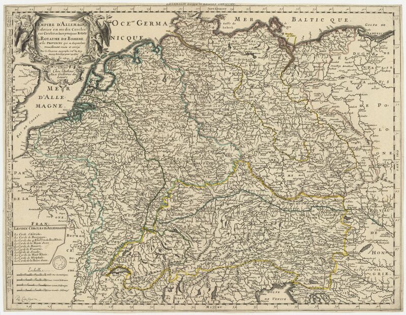
l'empire d'allemagne divisé en ses dix cercles en leurs principaux estats. le royaume de bohême et les provinces qui en dépendent - nouvellement reveu et corrigé par le sieur sanson... ; lud. cordier... - btv1b532023318
sanson maps of the circles of germany
maps from gallica
guides joanne
zee custe van sweeden, ontrent de westerwijck, ende tgatt vann stockholm, beginnende van kalmar tot den wigsteen en rookoe gelegen bynnen tgatt van stockholm alsoe hem tlandt daer verthoont - doer lucas... - btv1b53235860x
bibliothèque nationale de france
bibliothèque nationale de france
félix robaut
verthoninghe van de zee custen van bretaignen ; soe hem tlandt aldaer roter zee opdoet ; tusschen s- malo ende rouscou - doer lucas iansz waghenaer va(n) enchuijsen 1583 ; ioa(nn)es à doetecu(m) fecit - btv1b531566977
bibliothèque nationale de france
bibliothèque nationale de france
félix robaut
bibliothèque nationale de france
félix robaut
zee custe van sweeden, ontrent de westerwijck, ende tgatt vann stockholm, beginnende van kalmar tot den wigsteen en rookoe gelegen bynnen tgatt van stockholm alsoe hem tlandt daer verthoont - doer lucas... - btv1b53235860x
bibliothèque nationale de france
yiddish-language children's book covers
expressionism
maps of the byzantine levant
1650s maps showing history
american impressionism
1896 posters of france
chile in art by johann moritz rugendas
johann moritz rugendas
18th-century maps of central america
1760s maps of the caribbean
alphabet
literacy
engravings by george cruikshank
medicine in art
myths of the hindus & buddhists illustrations
paintings of shiva
maps by william home lizars
1836 maps of mexico
bibliothèque nationale de france
félix robaut
bibliothèque nationale de france
hendrik de leth
bibliothèque nationale de france
ambroise tardieu
bibliothèque nationale de france
félix robaut
bibliothèque nationale de france
félix robaut
verthoninghe van de zee custen van bretaignen ; soe hem tlandt aldaer roter zee opdoet ; tusschen s- malo ende rouscou - doer lucas iansz waghenaer va(n) enchuijsen 1583 ; ioa(nn)es à doetecu(m) fecit - btv1b531566977
bibliothèque nationale de france
verthoninghe van de zee custen van bretaignen ; soe hem tlandt aldaer roter zee opdoet ; tusschen s- malo ende rouscou - doer lucas iansz waghenaer va(n) enchuijsen 1583 ; ioa(nn)es à doetecu(m) fecit - btv1b531566977
bibliothèque nationale de france
plano de la bahia de argel situada en la costa de africa - explicacion del ataque que executo en esta bahia el ex.mo señor don antonio barcelo, siendo su mayor general el capitan de navio don joseph... - btv1b53238422p
maps by tomas lopez
zee custe van sweeden, ontrent de westerwijck, ende tgatt vann stockholm, beginnende van kalmar tot den wigsteen en rookoe gelegen bynnen tgatt van stockholm alsoe hem tlandt daer verthoont - doer lucas... - btv1b53235860x
bibliothèque nationale de france
bibliothèque nationale de france
félix robaut
bibliothèque nationale de france
félix robaut
yiddish-language children's book covers
expressionism
josef anton selb
quackery in art
an accurate map of england and wales , drawn from all the particular surveys hitherto publish'd. illustrated with many additional improvements, and regulated by numerous astronomical observations made by... - btv1b53181614s
maps by thomas kitchin
bibliothèque nationale de france
maps by thomas kitchin
sanson maps of the holy land
louis cordier
lycaonia et isauria in minores regiones seu tractus distinctae, et in iis romana itineraria, ex tabulâ peutingerianâ et ex antonino descripta - ex conatibus geographicis gulielmi sanson nicolai filii - btv1b531793912
guillaume sanson
human passions delineated (1773)
emotions in art
r2-d2
c-3po
capricho № 40: ¿de qué mal morirá?
romanticism,rococo
self-published work
cc-pd-mark
jean-fréderic phélypeaux
guillaume dheulland
prints by james gillray in the british museum
satirical prints in the british museum
ornament
food
a voyage to abyssinia, and travels into the interior of that country, executed under the orders of the british government in the years 1809 & 1810
john outhett
pharmacists in art
1882 lithographs
maps by william home lizars
1836 maps of mexico
ornament
food
invalid svg created with adobe illustrator:pictograms
svg created with inkscape and adobe illustrator
coats of arms of the netherlands antilles
pd dutch coat of arms
self-published work
blue svg icons
19th-century maps of vaucluse
1852 maps of france
a voyage to abyssinia, and travels into the interior of that country, executed under the orders of the british government in the years 1809 & 1810
john outhett
amérique méridionale (1748, d'anville)
rococo
18th-century maps of kent
maps by thomas kitchin
map of ancient armenia by philippe de la rué
bibliothèque nationale de france
die zee custe van tland van poictou ende bordeaux tuschen picqueliers ende de riviere van bordeaux alsoe hem tlant aldaer vuijt der zee opdoet ende verthoont - btv1b53156768t
bibliothèque nationale de france
die zee custe van tland van poictou ende bordeaux tuschen picqueliers ende de riviere van bordeaux alsoe hem tlant aldaer vuijt der zee opdoet ende verthoont - btv1b53156768t
bibliothèque nationale de france
midle-sex described with the most famous cities of london and westminster (1610)
context files from gallica
midle-sex described with the most famous cities of london and westminster (1610)
bibliothèque nationale de france
map of ancient armenia by philippe de la rué
bibliothèque nationale de france
die zee custe van tland van poictou ende bordeaux tuschen picqueliers ende de riviere van bordeaux alsoe hem tlant aldaer vuijt der zee opdoet ende verthoont - btv1b53156768t
bibliothèque nationale de france
old maps of northumberland
maps by thomas kitchin
an accurate map of england and wales , drawn from all the particular surveys hitherto publish'd. illustrated with many additional improvements, and regulated by numerous astronomical observations made by... - btv1b53181614s
maps by thomas kitchin
maps by willem and johannes blaeu
1630s maps of the americas
nice
good
hippie
dove
pages using duplicate arguments in template calls
teaching illustrations for language learning
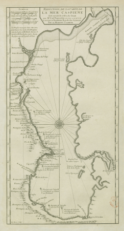
map of the caspian sea by guillaume delisle (1720s)
maps by gerard valck
18th-century maps of the caspian sea
claude auguste berey
maps of the south atlantic
guillaume dheulland
medical cartoons by james gillray
illustrations of gout
cynara cardunculus scolymus group
elizabeth blackwell (illustrator)
world war i posters in the library of congress
czech-language posters
engravings from the bible in the rijksmuseum amsterdam
tower of babel in engravings
nice
good
17th-century maps of west africa
1650 maps of africa
17th-century maps of pembrokeshire
maps by jodocus hondius ii
french-language maps
david du vivier
woman
job
woman
job
16th-century paintings of cupid (eros)
de aetatibus mundi imagines
15601 - 15700 of 16,724
Next page
/ 168


![Alsace divided into its main parts: namely the landgraviates of Upper and Lower Alsace and the Suntgaw / by Mr. Sanson, ...; Cordier sculpted; [cartouche] S[imonneau] f., 1700](https://cdn.creazilla.com/illustrations/10000469742/alsace-divided-into-its-main-parts-namely-the-landgraviates-of-upper-and-lower-alsace-and-the-suntgaw-by-mr-sanson-cordier-sculpted-cartouche-simonneau-f-1700-sm.webp)


![Road map of the Nord department / published by F[éli]x Robaut, author of geographical maps,...; litho. by F[éli]x Robaut in Douai; Ed. Boldoduc lith., Félix Robaut, 1849](https://cdn.creazilla.com/illustrations/10001301928/road-map-of-the-nord-department-published-by-flix-robaut-author-of-geographical-maps-litho-by-flix-robaut-in-douai-ed-boldoduc-lith-flix-robaut-1849-sm.webp)


![Road map of the Pas-de-Calais department / published by Félix Robaut, author of geographical maps,...; litho. by F[éli]x Robaut in Douai; Ed. Boldoduc lith., Félix Robaut, 1848](https://cdn.creazilla.com/illustrations/10000580589/road-map-of-the-pas-de-calais-department-published-by-flix-robaut-author-of-geographical-maps-litho-by-flix-robaut-in-douai-ed-boldoduc-lith-flix-robaut-1848-md.jpg)


![Map of France divided by provinces and departments with the population of each capital and its distance from Paris in kilometers / lith. by F[éli]x Robaut, Félix Robaut, 1845](https://cdn.creazilla.com/illustrations/10000876748/map-of-france-divided-by-provinces-and-departments-with-the-population-of-each-capital-and-its-distance-from-paris-in-kilometers-lith-by-flix-robaut-flix-robaut-1845-sm.webp)


![Road map of the Nord department / published by F[éli]x Robaut, author of geographical maps...; litho. by F[éli]x Robaut in Douai; Ed. Boldoduc lith., Félix Robaut, 1847](https://cdn.creazilla.com/illustrations/10000240353/road-map-of-the-nord-department-published-by-flix-robaut-author-of-geographical-maps-litho-by-flix-robaut-in-douai-ed-boldoduc-lith-flix-robaut-1847-sm.webp)
![Map of communications in the North of France and part of Belgium including all railways, roads, canals and navigable rivers / executed and published F[éli]x Robaut, ..., Félix Robaut, 1843](https://cdn.creazilla.com/illustrations/10000462604/map-of-communications-in-the-north-of-france-and-part-of-belgium-including-all-railways-roads-canals-and-navigable-rivers-executed-and-published-f-li-x-robaut-f-lix-robaut-1843-sm.jpg)


![An accurate Map of Dorset shire: drawn from the best maps charts etc. & regulated by astron[omy] observ[atio]ns / by T. Kitchin, Thomas Kitchin](https://cdn.creazilla.com/illustrations/10000227853/an-accurate-map-of-dorset-shire-drawn-from-the-best-maps-charts-etc-regulated-by-astronomy-observations-by-t-kitchin-thomas-kitchin-md.jpg)


![Midle-Sex described with the most famous cities of London and Westminster / Described by Iohn Norden; Augme[n]ted by I. Speed; Jodocus Hondius caelavit, 1610](https://cdn.creazilla.com/illustrations/10001372370/midle-sex-described-with-the-most-famous-cities-of-london-and-westminster-described-by-iohn-norden-augmented-by-i-speed-jodocus-hondius-caelavit-1610-md.jpg)
![Midle-Sex described with the most famous cities of London and Westminster / Described by Iohn Norden; Augme[n]ted by I. Speed; Jodocus Hondius caelavit, 1610](https://cdn.creazilla.com/illustrations/10001324000/midle-sex-described-with-the-most-famous-cities-of-london-and-westminster-described-by-iohn-norden-augmented-by-i-speed-jodocus-hondius-caelavit-1610-md.jpg)