357.055 Gambar gratis untuk Map
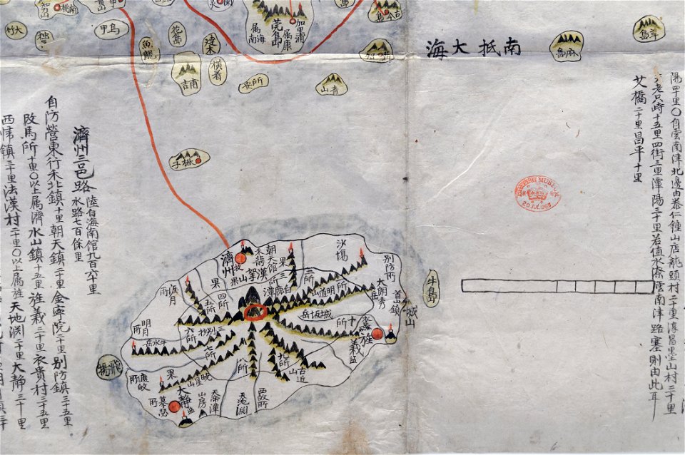
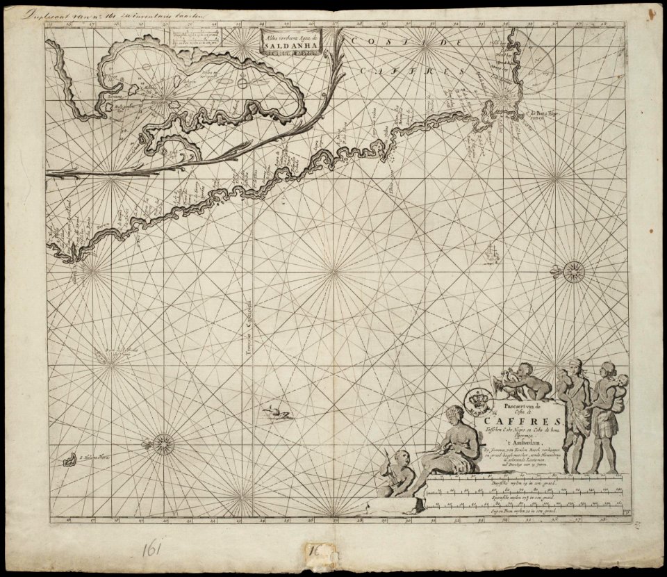
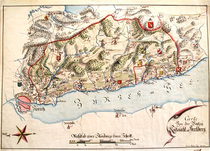
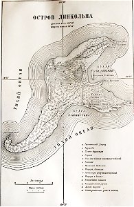
TrK60-Rommerskirchen A1
Tito Zanardelli - Essai d’une carte de la Belgique donnant les noms des lieux d’après leurs patois respectifs, 1890
AMH-7034-KB Map of the island of Onrust off the coast of Batavia
1632 Cardona Descripcion Indias (15)
Map of the Jeolla Province British Library c.27.f.14 fol.12 n01
Map of the Jeolla Province British Library c.27.f.14 fol.12 n02
AMH-7673-NA Map of the African coast between Cabo Negro and Cape of Good Hope
Vogtei Küsnacht 1779
Жюль Верн Карта Таинственного острова
Partie occidentale du Canada ou de la Nouvelle France ou sont les Nations des Ilinois, Coronelli, 1688 (détail Niagara)
Franz Johann Joseph von Reilly, Das Herzogthum Geldern Kurbrandenburgischen Antheils mit dem Fürstenthume Mörs (Nro. 268, 1794–1795)
Franz Johann Joseph von Reilly, Des Herzogthums Iülich Noerdliche Aemter mit den Herrschaften Wickerad Mylendonk und Kerpen (Nro. 286, 1794–1795)
Bellin - Ville de Manathe ou Nouvelle-Yorc
(1846) Karte der Krim-Chanate in der Ukraine und Südrusslands, Grenzverschiebungen vom 16. bis 17. Jahrhundert
Accuratissima regnorum Sueciae, Daniae et Norvegiae tabula - CBT 5871280
A most perfect description of the sea coastes of the north east land parte of Norway parte of Swedeland as it lieth betwene Distelbergh and Waersbergh RMG F8016
Atlas Van der Hagen-KW1049B10 016-DUCATVS SIESWICVM sive IVTIA AVSTRALIS
Atlas Van der Hagen-KW1049B10 003-REGIONES SVB POLO ARCTICO
Atlas Van der Hagen-KW1049B11 095-T Eylandt Walcheren is groot 43242 Gemeten 128 1-2 Roed.
Atlas Van der Hagen-KW1049B10 068-DUCATUS BREMAE & FERDAE Maximaeque partis FLUMINIS VISURGIS
Atlas Van der Hagen-KW1049B12 013-Accuratissima PRINCIPATUS CATALONIAE et COMITATUUM RUSCINONIS et CERRETANIAE DESCRIPTIO
Atlas Van der Hagen-KW1049B13 067-REGNA CONGO et ANGOLA
Atlas Van der Hagen-KW1049B12 070-TERRITORIO DI PAVIA, LODI, NOVARRA, TORTONA, ALLESSANDRIAAA et altri vicini dello Stato di Milano
Atlas Van der Hagen-KW1049B12 047-GENERALIS LOTHARINGIA DUCATUS TABULA, qua accuratissimé ostenduntur DUCATUS LOTHARINGIAE PROPRIAE ET BARRENSIS
Atlas Van der Hagen-KW1049B13 039-XANTVNG SINARVM IMPERII PROVICIA QUARTA
Atlas Schoemaker-WESTFRIESLAND-DEEL1-184-Noord-Holland, Bijlmermeer
Algérie, colonie française (région du sud) - Fonds Ancely - B315556101 A LEVASSEUR 090
Cosmographia - Beschreibung aller Lender durch Sebastianum Munsterum (1545) 25
Blaeu 1645 - Ducatus Brunsuicensis fereque Lunæburgensis cum adjacentibus episcopatibus comit domin etc
Du Halde - Description de la Chine - Villes de la province de Koei Tcheou
Dépt. de la Meurthe (région du nord-est) - Fonds Ancely - B315556101 A LEVASSEUR 057
Le comté de Nice et Oneille
Mapa Moravy z pol.18. století
Maximi totius Europae fluminis Danubii cursus per Germaniam Hungariamque nova delineatio - CBT 5873409
Goldfelder Witwatersrand 1888
Fort Rammekens of Zee-Burg
Italien-Karte2 Alpenkarte vom Großen St Bernhard bis an die Friaul-Küste 16Jh ubs G 0601 III
Insulae Maltae et Gozae - CBT 5882690
Ile de la Réunion - Colonie Française (Océan indien) (hémisphère austral) - Fonds Ancely - B315556101 A LEVASSEUR 091
Hochstift Strasburg 1791
Regni Siciliae et insulae Maltae et Gozae cum omnibus adjacentibus insulis... - CBT 5882690
SE South America RMG F1753
Partie occidentale du Canada ou de la Nouvelle France ou sont les Nations des Ilinois, Coronelli, 1688
Map of the Sea of Azov. George Dodd. Pictorial history of the Russian war 1854-5-6
Afbeelding van alle Nederlandse vestingsteden die in 1672 veroverd werden - Dutch fortified cities taken in 1672
1855 Spruner Map of Africa since the beginning of the 15th century - Geographicus - Africa1400-spruner-1855
AMH-6610-KB Map of the Cape of Good Hope, with an inset showing the bay of Augusto de Santa Bras on Madagascar and a view of the Cape of Good Hope
Huber Praha 1769 Cyriaken-Kloster und Kloster der Barmherzigen Brüder
1855 Spruner Map of Africa from the 8th to the 14th century - Geographicus - Africa700-1300-spruner-1855
1855 Spruner Map of Africa up to the Arab conquests in the 7th century - Geographicus - Africa600-spruner-1855
Cambrai map
Atlas Van der Hagen-KW1049B12 012-ARRAGONIA REGNVM
Atlas Van der Hagen-KW1049B13 079-YUCATAN Conventus Iuridici Hispaniae Novae Pars Occidentalis, et GVATIMALA CONVENTVS IVRIDICVS
Amérique septentrionale - Fonds Ancely - B315556101 A LEVASSEUR 099
Hugo-de-Groot-Grollæ-obsidio-cvm-annexis-anni-M-DC-XXVII MG 0153
Torino's map (1674)
AMH-6815-KB Map of part of the Chinese coast
Die Neubildung des preussischen Staat
Memoires-des-commissaires-du-roi-et-de-ceux-de-sa-majesté-brittanique MG 9386
Lilla- och Stora Träskan
Galliae christianae Moguntinensis
Galliae christianae Narbonensis
Galliae christianae Remensis 2
Galliae Christianae Provincia Ecclesiastica Trevirensis
Galliae christianae provincia ecclesiastica Viennensis
Galliae christianae Provincia Cameracensis
Galliae christianae Coloniensis cis Rhenum
Galliae christianae Rotomagensis
Galliae christianae Provincia ecclesiastica Parisiensis
Galliae christianae provincia Mechliniensis
Galliae christianae Provincia ecclesiastica Ebredunensis
View of Washington City. LOC 90683459
View of East Boston, Mass. 1879. LOC 75694566
View of Washington City. LOC 90683459
View of East Boston, Mass. 1879. LOC 75694566
Zentralbibliothek Solothurn - Das Hochstift Basel - Die Grafschaft Hanau-Lichtenberg - aa0069
7301 - 7400 dari 357.055 Halaman berikutnya
/ 3571